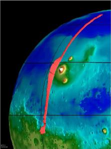
A representation of the Tharsis Ridge, showing the altitude of the volcanoes compared to the surrounding areas. The elevated southern hemisphere is also shown. From Mars Global Surveyor.
Click on image for full size
NASA/JPL
The Tharsis Ridge
This image, taken from the Mars Global Surveyor mission (MGS), shows the Tharsis Ridge, the green/blue area in the middle of the picture, as well as a portion of the southern hemisphere of Mars. The green areas are higher than the surroundings, and the yellow/white regions, which are actually Martian volcanoes, are the highest of all. The red line in the picture is the spacecraft measurement which indicates just how large the regions are compared to one another.
The Tharsis Ridge is a region about twice the size of the United States (8000 km), and is where many of the volcanoes of Mars are found. Measurements by all spacecraft visiting Mars, including recent ones by Mars Pathfinder and Mars Global Surveyor have indicated that this region of Mars is actually a giant bulge, as shown in the picture. The picture also shows how much higher the southern hemisphere of Mars is than the rest of the planet.
The Ridge probably formed somewhat late in Mars' history. This means that Mars probably had a late warming period, which created the Ridge, with it's volcanoes. The Ridge may have been built in a manner similar to the volcanic rises of Venus, namely by a rising hot balloon of material from the deep interior, which formed land on the surface. The cratering record suggests that after this period of activity, all volcanic activity on Mars ceased.
You might also be interested in:

The largest volcano in the solar system is Olympus Mons, shown in the image to the left. Olympus Mons is a Martian shield volcano. The altitude of Olympus Mons is three times the altitude of the largest
...more
On this map of Mars, the lightly cratered Tharsis Ridge is shown, as well as the heavily cratered Martian highlands (near the bottom of the picture), and Valles Marineris to the right. The volcanoes are
...more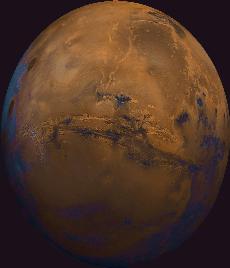
Next to the Tharsis Ridge is Valles Marineris. Valles Marineris is a large system of canyons that stretches 4000 km (2500 mi) along the equator of Mars. It was first imaged in detail by Mariner 9. As can
...more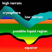
On Mars, the water is trapped, frozen, within the ground. Nevertheless, there is evidence for running water on Mars. When the water is melted and released to the surface, it will run from higher ground
...moreThe drawing shows a crossection of the crust, and the unusual altitude variation of the Martian surface. The figure illustrates the depth of frozen ground at various latitudes, called the cryosphere. The
...more
Separate from the Martian outflow channels, or the river valley networks, are large Martian lakes (600 km, or ~1000 miles across) which exhibit evidence of a periodic and catastrophic release of water
...more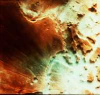
This is an image of fog in a Martian canyon. The presence of fog provides evidence of water, and a water cycle on Mars. More fog has been seen in images returned by Mars Global Surveyor of the south polar
...more
The Martian climate is more influenced by the shape of the Martian orbit than the climate of the Earth is influenced by the shape of the Earth's orbit. The orbit of Mars is more oval-shaped than that
...more