Water

Water is found in many places on Earth including on the surface of the planet, within rocks below the surface, and in the atmosphere.  Water travels between different areas of the Earth through the water cycle. About 70% of the Earth surface is covered with water, and most of that is the ocean. Only a small portion of the Earth's water is freshwater, which is found in rivers, lakes, and groundwater. Freshwater is needed for drinking, farming, and washing. In addition to liquid water, water is also present on Earth in the form of ice. Without water, life as we know it would not exist.
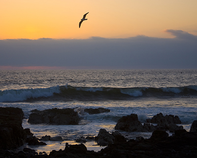
This beautiful sunset was captured off the coast of Chile in October,
  2009. Earth's ocean covers more than 70% of our planet's surface. <a
  href="/earth/Water/ocean_motion.html&dev=1">Ocean
  water is always moving</a>. It moves around by <a
  href="/earth/Water/ocean_currents.html&dev=1">surface
  ocean currents</a>, <a
  href="/earth/Water/ocean_upwelling.html&dev=1">upwelling</a>,
  <a
  href="/earth/Water/ocean_tides.html&dev=1">tides</a>,
  and the <a
  href="/earth/Water/circulation1.html&dev=1">global
  ocean conveyor</a> or <a
  href="/earth/Water/circulation1.html&dev=1">thermohaline
  circulation</a>. The ocean's tides are one type of tide created by <a
  href="/glossary/tidal_forces.html&dev=1">gravitational
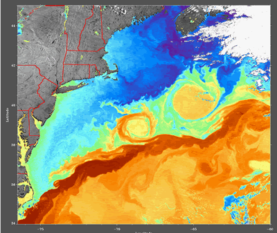
  force</a>.<p><small><em>Image courtesy of Carlye Calvin</em></small></p>Two large warm water eddies are swirling to the north of the <a href="/earth/Water/gulf_stream.html&dev=1">Gulf Stream current</a> in this satellite image recorded with the AVHRR sensor (Advanced Very High Resolution Radiometer) aboard a NOAA satellite on June 11, 1997. Blue colors indicate cooler water, while yellow and orange colors indicate warmer water.<p><small><em>Courtesy of the Ocean Remote Sensing Group, Johns Hopkins University Applied Physics Laboratory</em></small></p>The <a
  href="/earth/Water/circulation1.html&dev=1">thermohaline
  circulation</a>, often referred to as the ocean's "conveyor belt",
  links major surface and deep water currents in the Atlantic, Indian, Pacific,
  and Southern Oceans. This pattern is driven by changes in water <a
  href="/earth/Water/temp.html&dev=1">temperature</a>
  and <a
  href="/earth/Water/salinity.html&dev=1">salinity</a>
  that change the <a
  href="/earth/Water/density.html&dev=1">density</a>
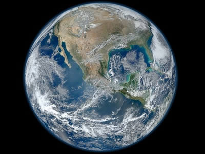
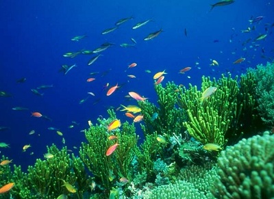
  of seawater.<p><small><em> Image courtesy <a href="http://www.clivar.org/publications/other_pubs/clivar_transp/d3_transp.htm">CLIVAR</a> (after W. Broecker, modified by E. Maier-Reimer).</em></small></p>A new study has found that <a href="/earth/Atmosphere/airpollution_intro.html&dev=1">pollution</a> from <a href="/earth/Atmosphere/particulates.html&dev=1">fine particles</a> in the air - mainly the result of burning coal or <a href="/earth/interior/eruptions.html&dev=1">volcanic eruptions</a> - can shade <a href="/earth/Life/cnidarian.html&dev=1">corals</a> from sunlight and cool the surrounding water resulting in reduced growth rates.  Coral growth rates in the Caribbean were affected by volcanic aerosol emissions in the early 20th century and by aerosol emissions caused by humans in the later 20th century.  For more information, see the <a href="http://www.exeter.ac.uk/news/featurednews/title_278202_en.html">press release</a>.<p><small><em>Image courtesy of Toby Hudson (Wikimedia Commons)</em></small></p>The massive 9.0 magnitude <a href="/earth/geology/quake_1.html&dev=1">earthquake</a> off of Honshu, Japan on <a href="/headline_universe/march112011earthquaketsunami.html&dev=1">11 March 2011</a> generated a <a href="/earth/tsunami1.html&dev=1">tsunami</a> that exceeded 10 meters on the coast near the epicenter.  This image shows model projections for the tsunami wave height in cm which are in good agreement with the observed waves. Our thoughts and prayers are with those who were lost, and their families, as we remember this event.<p><small><em><a href="http://blogs.agu.org/wildwildscience/files/2011/03/680_20110311-TsunamiWaveHeight.jpg">NOAA Tsunami Wave Height Projections image</a></em></small></p>This image is a montage of high resolutions photographs of the Earth taken in January 2012 by the Visible/Infrared Imager Radiometer Suite (VIIRS) instrument on the Suomi NPP satellite.  The image shows many stunning details of <a href="http://www.windows2universe.org/earth/earth.html">our home planet</a> - <a href="http://solarsystem.nasa.gov/multimedia/gallery/VIIRS_4Jan2012.jpg">particularly at high resolution</a>. The beauty of our planet is obvious from space - our blue <a href="http://www.windows2universe.org/earth/Water/overview.html">waters</a>, our white <a href="http://www.windows2universe.org/earth/Atmosphere/cloud.html">clouds</a>, and the green from <a href="http://www.windows2universe.org/earth/Life/life.html">life</a> abundant at the surface.<p><small><em>Image courtesy of NASA</em></small></p>

Windows to the Universe, a project of the National Earth Science Teachers Association, is sponsored in part is sponsored in part through grants from federal agencies (NASA and NOAA), and partnerships with affiliated organizations, including the American Geophysical Union, the Howard Hughes Medical Institute, the Earth System Information Partnership, the American Meteorological Society, the National Center for Science Education, and TERC. The American Geophysical Union and the American Geosciences Institute are Windows to the Universe Founding Partners. NESTA welcomes new Institutional Affiliates in support of our ongoing programs, as well as collaborations on new projects. Contact NESTA for more information. NASA ESIP NCSE HHMI AGU AGI AMS NOAA