This map of South America includes the Southeast Pacific region, including the Southeast Pacific Ocean, the coastal regions of Peru and Chile, and the Andes Mountains.
Click on image for full size
Image Courtesy of NASA's Earth Observatory

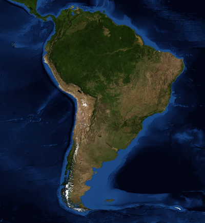
The Southeast Pacific Region

The Southeast Pacific (SEP) region contains a variety of landscapes and weather conditions. The SEP includes the land that is on the coastal side of the Andes mountains in the central and northern parts of Chile and much of Peru. This extremely diverse region of South America extends from equatorial Peru south to central Chile.

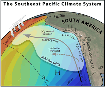
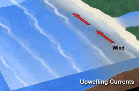
The climate of the SEP is influenced by numerous factors. This dry area is cooled by the Humboldt Current and upwelling, which produces one of the largest fisheries in the world. Periodically, the El Niño Southern Oscillation (ENSO) causes shifts in winds and ocean currents. These changes can cause extremes amounts of precipitation and flooding, droughts, and reductions in the amount of upwelling along the coast. The towering Andes cause winds to flow along the coast rather than east across the continent.

The coast of Peru and northern Chile consists of a subtropical desert climate. The land in this region rises up vertically from the ocean; this topography helps trap the coastal fog that often forms over the cold ocean waters. Fog is common in the area, and the only precipitation is an occasional light drizzle. Beyond these coastal bluffs is the Atacama Desert, one of the driest places on the Earth. The Atacama Desert contains great mineral wealth, especially copper.

Central Chile has a mild, temperate Mediterranean climate. Rainfall increases towards the south and numerous rivers flow in this region due to winter rainfall along the coast and spring snowmelt in the Andes. This part of Chile also contains a coastal mountain range that runs parallel to the Andes and creates the Central Valley.

Chile has a number of island territories located in the Pacific Ocean, including Easter Island. Easter Island is located 3,600 km (2,237 miles) off the coast of Chile and has a humid, subtropical climate.

Last modified August 29, 2008 by Dennis Ward.

You might also be interested in:

Cool It! Game

Check out our online store - minerals, fossils, books, activities, jewelry, and household items!...more

Southeast Pacific Climate

There are several regions in the world where low-lying stratus and stratocumulus clouds are frequently present and an important part of climates. It turns out that these regions also play an important...more

Surface Ocean Currents

The water at the ocean surface is moved primarily by winds. Large scale winds move in specific directions because they are affected by Earth’s spin and the Coriolis Effect. Because Earth spins constantly,...more

Ocean Upwelling

In areas of upwelling, deep ocean water makes its way to the surface. This has an impact on marine life as well as the region's climate. Upwelling happens commonly along coastlines. Winds blowing parallel...more

Fisheries in the Southeast Pacific Region

If you like anchovies on your pizza, there is a good chance that the little fish now swimming in tomato sauce was once swimming in the water of the Southeastern Pacific (SEP) Ocean. The deep, cold, and...more

Wind

Wind is moving air. Warm air rises, and cool air comes in to take its place. This movement creates different pressures in the atmosphere which creates the winds around the globe. Since the Earth spins,...more

What is Climate?

Climate in your place on the globe is called regional climate. It is the average weather pattern in a place over more than thirty years, including the variations in seasons. To describe the regional climate...more

Fog

Fog is a ground-level cloud. There are several ways that fog forms. It usually forms when moist air travels over cold land or water. The moist air cools down and the water vapor condenses and forms a cloud...more

Windows to the Universe, a project of the National Earth Science Teachers Association, is sponsored in part is sponsored in part through grants from federal agencies (NASA and NOAA), and partnerships with affiliated organizations, including the American Geophysical Union, the Howard Hughes Medical Institute, the Earth System Information Partnership, the American Meteorological Society, the National Center for Science Education, and TERC. The American Geophysical Union and the American Geosciences Institute are Windows to the Universe Founding Partners. NESTA welcomes new Institutional Affiliates in support of our ongoing programs, as well as collaborations on new projects. Contact NESTA for more information. NASA ESIP NCSE HHMI AGU AGI AMS NOAA