This photo, taken from space, shows the Southeast Pacific Ocean on the left, with patches of stratocumulus clouds along the coast of South American. Moving to the right (east) one can see the low lying coastal Atacama Desert and the Andes Mountain Range.
Click on image for full size
Image Courtesy of NASA
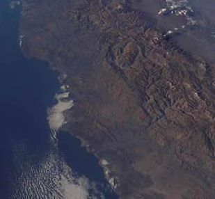
The Andes Mountains

The Andes Mountains form one of the longest mountain ranges on Earth, stretching over 7,000 km (4,400 miles) along the west coast of South America. The Andes are very narrow in most places and the average width of the Andes is 200 km (124 miles). The height of the Andes is about 4,000 meters (13,123 feet) high, and it includes peaks above 6,000 meters (19,685 feet). Aconcagua, the highest peak in the Andes, is 6,962 meters (22,841 feet). Many of the peaks in the Andes are active volcanoes. The mountain range is part of seven countries: Argentina, Bolivia, Chile, Colombia, Ecuador, Peru, and Venezuela .

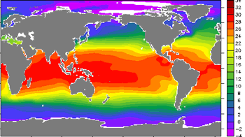
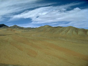
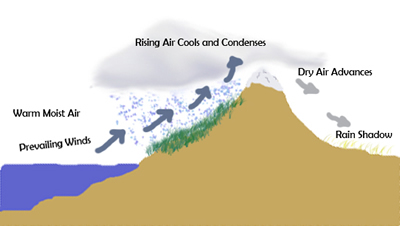
The Andes are a massive barrier between the eastern Pacific Ocean and the rest of the continent of South America. This barrier impacts the climate of South America. The northern part of the Andes is typically rainy and warm. The west side of the central Andes is extremely dry and includes the Atacama Desert in northern Chile; the eastern portion of the central Andes is much wetter. In the south, the western side of the Andes tends to be wet, while the eastern plains of Argentina are in a rain shadow and tend to be very dry. Many of the peaks in the Andes receive heavy snowfall and contain glaciers.

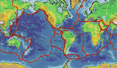
The forces of plate tectonics are responsible for the formation of the Andes. The Nazca plate and a part of the Antarctic plate have been subducting beneath the South American plate, which is a process that continues today and causes earthquakes and volcanic eruptions in the region.

The Inca Empire started in the mountains of Peru in the early 13th century and spread throughout the Andes in the 1400s. The Incas built roads and aqueducts throughout the mountain range. Inca engineers constructed impressive sites, including the capital city of Cuzco and Machu Picchu. In the 1530s a civil war and exposure to European diseases destroyed most of the Inca Empire.

Last modified November 17, 2008 by Julia Genyuk.

You might also be interested in:

Traveling Nitrogen Classroom Activity Kit

Check out our online store - minerals, fossils, books, activities, jewelry, and household items!...more

What Is Climate?

The climate where you live is called regional climate. It is the average weather in a place over more than thirty years. To describe the regional climate of a place, people often tell what the temperatures...more

Atacama Desert

The Atacama Desert is one of the driest places on Earth. The Atacama is in the country of Chile in South America. In an average year, much of this desert gets less than 1 millimeter (0.04 inch) of rain!...more

Rain Shadow

A rain shadow is a dry region of land on the side of a mountain range that is protected from the prevailing winds. Prevailing winds are the winds that occur most of the time in a particular location on...more

Glaciers and Ice Sheets

For a glacier to develop, the amount of snow that falls must be more than the amount of snow that melts each year. This means that glaciers are only found in places where a large amount of snow falls each...more

Plate Tectonics

The main force that shapes our planet's surface over long amounts of time is the movement of Earth's outer layer by the process of plate tectonics. This picture shows how the rigid outer layer of the Earth,...more

Subduction

When two sections of the Earth's crust collide, one slab of crust can be forced back down into the deeper regions of the Earth, as shown in this diagram. This process is called subduction. The slab that...more

What Is an Earthquake?

The expression "on solid ground" is often used to describe something as stable. Usually the solid ground underfoot seems very stable. But sometimes it is not. "The ground seemed to twist under us like...more

Windows to the Universe, a project of the National Earth Science Teachers Association, is sponsored in part is sponsored in part through grants from federal agencies (NASA and NOAA), and partnerships with affiliated organizations, including the American Geophysical Union, the Howard Hughes Medical Institute, the Earth System Information Partnership, the American Meteorological Society, the National Center for Science Education, and TERC. The American Geophysical Union and the American Geosciences Institute are Windows to the Universe Founding Partners. NESTA welcomes new Institutional Affiliates in support of our ongoing programs, as well as collaborations on new projects. Contact NESTA for more information. NASA ESIP NCSE HHMI AGU AGI AMS NOAA