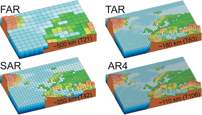
These images illustrate the typical spatial resolution used in state-of-the-art climate models around the times of each of the four IPCC Assessment Reports. Around the time of the First Assessment Report (FAR) in 1990, many climate models used a grid with cells of about 500 km (311 miles) on a side (upper left image). By the time of the the Second Assessment Report (SAR) in 1996, resolution had improved by a factor of two, producing grid cells 250 km (155 miles) on a side. Models references in the Third Assessment Report (TAR) in 2001 generally had reduced grid cells sizes to about 180 km (112 miles), while Fourth Assessment Report (AR4) models typically used a 110 km (68 mile) wide grid cell, further improving resolution. Vertical resolution is not depicted in these images, but has also improved over the years. Typical FAR models had a single-layer "slab ocean" and 10 atmospheric layers; AR4 models often include 30 layers in the oceans and another 30 in the atmosphere. Notice how elements of topography, such as the Alps Mountains, are shown in much greater detail in higher-resolution models. This allows such models to begin to make reasonable forecasts of regional climate in the future, a currently emerging capability.
Image courtesy of the IPCC (AR4 WG 1 Chapter 1 page 113 Fig. 1.4)
Last modified April 22, 2009 by Lisa Gardiner.

You might also be interested in:

Cool It! Game

Check out our online store - minerals, fossils, books, activities, jewelry, and household items!...more

World Leaders Developing a New Plan to Help Earth’s Changing Climate

Leaders from 192 nations of the world are trying to make an agreement about how to limit emissions of heat-trapping greenhouse gases, mitigate climate change, and adapt to changing environmental conditions....more

What is Climate?

Climate in your place on the globe is called regional climate. It is the average weather pattern in a place over more than thirty years, including the variations in seasons. To describe the regional climate...more

Earth's Greenhouse Gases

Less than 1% of the gases in Earth's atmosphere are called greenhouse gases. Even though they are not very abundant, these greenhouse gases have a major effect. Carbon dioxide (CO2), water vapor (H2O),...more

Space Missions to study Earth's Atmosphere & Climate

Television weather forecasts in the space age routinely feature satellite views of cloud cover. Cameras and other instruments on spacecraft provide many types of valuable data about Earth's atmosphere...more

Modeling the Future of Climate Change

Predicting how our climate will change in the next century or beyond requires tools for assessing how planet responds to change. Global climate models, which are run on some of the world's fastest supercomputers,...more

Effects of Climate Change Today

The world's surface air temperature increased an average of 0.6° Celsius (1.1°F) during the last century according to the Intergovernmental Panel on Climate Change (IPCC). This may not sound like very...more

What Controls the Climate?

A factor that has an affect on climate is called a “forcing.” Some forcings, like volcanic eruptions and changes in the amount of solar energy, are natural. Others, like the addition of greenhouse gases...more

Windows to the Universe, a project of the National Earth Science Teachers Association, is sponsored in part is sponsored in part through grants from federal agencies (NASA and NOAA), and partnerships with affiliated organizations, including the American Geophysical Union, the Howard Hughes Medical Institute, the Earth System Information Partnership, the American Meteorological Society, the National Center for Science Education, and TERC. The American Geophysical Union and the American Geosciences Institute are Windows to the Universe Founding Partners. NESTA welcomes new Institutional Affiliates in support of our ongoing programs, as well as collaborations on new projects. Contact NESTA for more information. NASA ESIP NCSE HHMI AGU AGI AMS NOAA