Two large warm water eddies are swirling to the north of the Gulf Stream current in this satellite image recorded with the AVHRR sensor (Advanced Very High Resolution Radiometer) aboard a NOAA satellite on June 11, 1997. Blue colors indicate cooler water, while yellow and orange colors indicate warmer water.
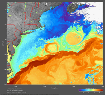
Click on image for full size
Courtesy of the Ocean Remote Sensing Group, Johns Hopkins University Applied Physics Laboratory

The Swirling Water of Ocean Eddies

Surface ocean currents move in predictable directions over time. However, on a smaller scale, the water in currents moves in complex and variable ways. And those complexities can cause some water to spin away from a current, creating an eddy.

The swirling water of an eddy can be more than 100 km (60 miles) in diameter. The center of some eddies is cool while the center of others is warm. Warm water eddies are usually nutrient poor and marine life is sparse in them. Cold water eddies are usually nutrient rich and full of life.

Eddies form when a bend in a surface ocean current elongates over time, making a loop. The loop separates from the main current to form the eddy. The Coriolis effect causes similar eddies to rotate in opposite directions in the different hemispheres so that in the north, cold water eddies rotate counterclockwise and warm water eddies rotate clockwise, while in the south, cold water eddies rotate clockwise and warm water eddies rotate counterclockwise. There is evidence that the topography of the ocean floor can help eddies to form too. Once an eddy forms, the swirling waters last for at least a few months.

The satellite image at the left of sea surface temperatures (SST) shows two large circular features above the Gulf Stream current in the Atlantic near the northeast coast of the United States. These are eddies. In this image, surface water is colored depending on its temperature with blues and purples for the coldest water and orange and yellow for warmer water. The orange color of these eddies indicates that they are warm water eddies. This area of the ocean – the Gulf Stream - tends to have some of the largest and most well defined eddies in the world.

Last modified January 8, 2010 by Randy Russell.

You might also be interested in:

Cool It! Game

Check out our online store - minerals, fossils, books, activities, jewelry, and household items!...more

Surface Ocean Currents

The water at the ocean surface is moved primarily by winds. Large scale winds move in specific directions because they are affected by Earth’s spin and the Coriolis Effect. Because Earth spins constantly,...more

Winds in the Southeast Pacific

Winds in the Southeast Pacific have a strong influence on regional climate and play an important role in several large-scale, global climate phenomena. The Hadley cell is a global atmospheric circulation...more

Ocean-Atmosphere Coupling in the Southeast Pacific

The ocean and the atmosphere in the Southeast Pacific Ocean are connected in many ways. Strong trade winds blow northward along the west coast of South America. These winds stir up the ocean, bringing...more

Introduction to VOCALS Science

How big of a 'laboratory' would you need to conduct experiments on a climate system? Well, that probably depends on which part of Earth's climate system you want to study. In the case of the VOCALS, the...more

Ocean Gyres

A gyre is another name for a swirling vortex. Ocean gyres are large swirling bodies of water that are often on the scale of a whole ocean basin or 1000’s of kilometers across (hundreds to thousands of...more

Aquifer

An aquifer is the name for a layer of rock which is capable of holding a large amount of water. Some layers are better at holding water than others, for example a layer of sandstone can hold a good deal...more

Carbonates

Carbonate is a name for rocks and minerals which contain a certain form of carbon/oxygen compound known as CO32-. (CO32- is also known as the molecule carbonate). Limestone is an example of a calcium carbonate,...more

Windows to the Universe, a project of the National Earth Science Teachers Association, is sponsored in part is sponsored in part through grants from federal agencies (NASA and NOAA), and partnerships with affiliated organizations, including the American Geophysical Union, the Howard Hughes Medical Institute, the Earth System Information Partnership, the American Meteorological Society, the National Center for Science Education, and TERC. The American Geophysical Union and the American Geosciences Institute are Windows to the Universe Founding Partners. NESTA welcomes new Institutional Affiliates in support of our ongoing programs, as well as collaborations on new projects. Contact NESTA for more information. NASA ESIP NCSE HHMI AGU AGI AMS NOAA