Some More Hurricane Images
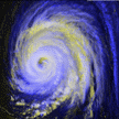
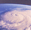
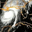
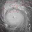
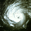 This hurricane is rotating counter-clockwise over Mississippi and
Louisiana. It was taken by a satellite, and you can see the eye of the
storm in the center. (84K GIF)
This hurricane is rotating counter-clockwise over Mississippi and
Louisiana. It was taken by a satellite, and you can see the eye of the
storm in the center. (84K GIF)
Image provided courtesy of University of Illinois Cloud Catalog
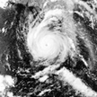
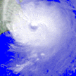
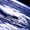 Hurricane Gladys in Tampa, Florida taken from Apollo 7 satellite.
(59K GIF)
Hurricane Gladys in Tampa, Florida taken from Apollo 7 satellite.
(59K GIF) Image provided courtesy of NASA
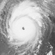
 This is an infrared satellite image of Hurricane Luis. This hurricane
lasted from August 29 - September 11, 1995. (71K GIF)
This is an infrared satellite image of Hurricane Luis. This hurricane
lasted from August 29 - September 11, 1995. (71K GIF) Image provided courtesy of EarthWatch Communications, Inc.
 This is another satellite image of Hurricane Luis in September 1995. It
was taken with the NOAA-14 AVHRR. (Near Virgin Islands) (71K GIF)
This is another satellite image of Hurricane Luis in September 1995. It
was taken with the NOAA-14 AVHRR. (Near Virgin Islands) (71K GIF)
Image provided courtesy of Atmospheric and Environmental Research, Inc.
 Another satellite image of Hurricane Luis on October 5, 1995.
(73K GIF)
Another satellite image of Hurricane Luis on October 5, 1995.
(73K GIF) Image provided courtesy of Atmospheric and Environmental Research, Inc.
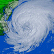
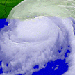
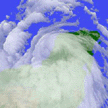
 Hurricane Andrew over the coast of Florida in 1992. This hurricane
lasted from August 16 - 28, 1992. (123K GIF)
Hurricane Andrew over the coast of Florida in 1992. This hurricane
lasted from August 16 - 28, 1992. (123K GIF)  This is an image history of Hurricane Hugo on September 22, 1989. They
are digital radar and infrared satellite images. (99K GIF)
This is an image history of Hurricane Hugo on September 22, 1989. They
are digital radar and infrared satellite images. (99K GIF)
Courtesy of UCAR UNIDATA Project and the University of Hawaii at Manoa
 This is a satellite image of Hurricane Elena. (14K GIF)
Image provided courtesy of NASA
 This is a visible image of Hurricane Emily (59K GIF)
Image provided courtesy of EarthWatch Communications, Inc.
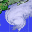
 This is a visible satellite image of Hurricane Felix on August 17, 1995.
(119K GIF)
This is a visible satellite image of Hurricane Felix on August 17, 1995.
(119K GIF) Image provided courtesy of EarthWatch Communications, Inc.
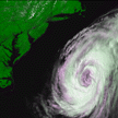 This is visible/Near Infrared Color Composite image of Hurricane Felix
as it pulls away from the East Coast. It was taken on August 18, 1995
with the NOAA-14AVHRR. (119K GIF)
This is visible/Near Infrared Color Composite image of Hurricane Felix
as it pulls away from the East Coast. It was taken on August 18, 1995
with the NOAA-14AVHRR. (119K GIF) Image provided courtesy of Atmospheric and Environmental Research, Inc.
 Hurricane Andrew over the coast of Louisiana in 1992. (43K GIF)
 This is an Infrared satellite image of Hurricane Opal taken on October 4,
1995. (113K GIF)
This is an Infrared satellite image of Hurricane Opal taken on October 4,
1995. (113K GIF) Image provided courtesy of EarthWatch Communications, Inc.
 This is an image of Hurricane Opal taken on October 4, 1995.
(53K GIF)
This is an image of Hurricane Opal taken on October 4, 1995.
(53K GIF)
 Another image of Hurricane Opal. (54K GIF)
 This is an Infrared satellite image of Hurricane Roxanne on October 11,
1995. (112K GIF)
This is an Infrared satellite image of Hurricane Roxanne on October 11,
1995. (112K GIF) Image provided courtesy of EarthWatch Communications, Inc.
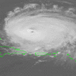
 This is a GOES image of a hurricane. (98K GIF)
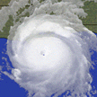 This is a visible image of Hurricane Andrew. (70K GIF)
Image provided courtesy of EarthWatch Communications, Inc.