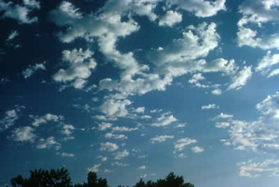
This is a photograph of altocumulus clouds.
Click on image for full size
Courtesy of UCAR Digital Image Library
Altocumulus
Altocumulus clouds are part of the Middle Cloud group (2000-7000m
up). They are grayish-white with one part of the cloud
darker than the other. Altocumulus clouds usually form in groups and are about
1 km thick.
Altocumulus clouds are about as wide as your thumb when you hold up your hand at arm's length to look at the cloud.
If you see altocumulus clouds on a warm humid morning, then expect thunderstorms by
late afternoon.
You might also be interested in:

The middle cloud group consists of Altostratus and Altocumulus clouds. Middle clouds are made of ice crystals and water droplets. The base of a middle cloud above the surface can be anywhere from 200
...more
Thunderstorms are one of the most thrilling and dangerous types of weather phenomena. Over 40,000 thunderstorms occur throughout the world each day. Thunderstorms form when very warm, moist air rises into
...more
Altostratus belong to the Middle Cloud group (2000-7000m up). An altostratus cloud usually covers the whole sky and has a gray or blue-gray appearance. The sun or moon may shine through an altostratus
...more
Stratocumulus clouds belong to the Low Cloud (surface-2000m) group. These clouds are low, lumpy, and gray. These clouds can look like cells under a microscope - sometimes they line up in rows and other
...more
Without meaning to, airplanes can cause certain types of clouds to produce snow or rain. When the aircraft climb or descend through mid-level clouds, if the atmospheric conditions are right then the planes
...more
Weather fronts can cause clouds to form. Fronts occur when two large masses of air collide at the Earth's surface. Warm fronts produce clouds when warm air replaces cold air by sliding above it. Many different
...more
Altocumulus clouds are part of the Middle Cloud group (2000-7000m up). They are grayish-white with one part of the cloud darker than the other. Altocumulus clouds usually form in groups and are about
...more


