On this image of the Earth, the horizontal (blue) lines represent lines of latitude and the vertical (pink) lines represent lines of longitude. The horizontal gray line represents the equator and the vertical gray line represents the Prime Meridian; both of these lines represent 0 degrees. The North Pole, at the top of the image, is where all of the lines of longitude come together.
Click on image for full size
Image Courtesy of Dennis Ward/UCAR

Latitude and Longitude

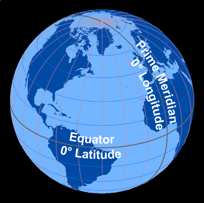
The most common way to locate points on the surface of the Earth is by standard, geographic coordinates called latitude and longitude. These coordinates are measured in degrees and represent angular distances calculated from the center of the Earth. On maps and globes, these are drawn as imaginary lines of latitude and longitude and help us determine locations.

Latitude describes the distance from the Earth's equator, with 0 degrees being the equator. The North Pole is +90 degrees and the South Pole is -90 degrees. Latitude is also described as being either “North” or “South,” depending on the position in relationship to the equator. The equator divides the Earth into Northern and Southern Hemispheres. A line connecting all the points with the same latitude value is called a line of latitude.

Longitude is the measurement either east or west from the Prime Meridian, a line of longitude which runs between the poles and through Greenwich, England. Longitude increases as you leave the Prime Meridian (0 degrees) going east (0 to 180 degrees) and decreases as you head west (0 to -180 degrees), until they meet at 180 degrees. The Prime Meridian divides the Earth into Eastern and Western Hemispheres. Why does the Prime Meridian go through Greenwich, England? It could be anywhere, but in the mid-1800s the Royal Observatory in Greenwich, England was well known for keeping time, and because the time is the same all along that line of longitude, it was decided that the Prime Meridian would go through Greenwich.

Here's an example of the latitude and longitude of a specific location. New York, NY, USA has a latitude of 40.75793 degrees (north) and a longitude of -73.98551 (west). This means New York, NY is approximately 41 degrees north of the equator and approximately 74 degrees west of the Prime Meridian.

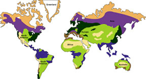
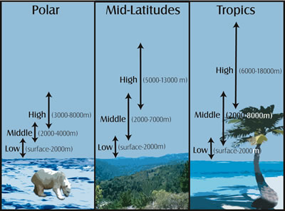
A region's latitude has a great effect on its climate because latitude determines the amount of solar energy a region receives. Low latitude locations, on or near the equator, are called the tropics. It's warm there because roughly the same amount of sunlight is received year-round. High latitude locations, at or near the poles, have a cold, polar climate. The closer you are to one of Earth's poles, the less sunlight there is during winter days. Mid-latitude climates in the areas between the tropics and polar regions have several distinct seasons throughout the year because the amount of sunlight changes from summer to winter.

Last modified July 23, 2008 by Becca Hatheway.

You might also be interested in:

Traveling Nitrogen Classroom Activity Kit

Check out our online store - minerals, fossils, books, activities, jewelry, and household items!...more

Climate Changes with Latitude

Places located at high latitudes (far from the equator) receive less sunlight than places at low latitudes (close to the equator). The amount of sunlight and the amount of precipitation affects the types...more

Cloud Heights at Different Latitudes

Different types of clouds can be found at different heights in the sky. In addition to cloud type determining its height, latitude plays a role in how high a cloud is in the sky. Most clouds we see, including...more

Surface Ocean Currents

The water at the ocean surface is moved primarily by winds that blow in certain patterns because of the Earth’s spin and the Coriolis Effect. Winds are able to move the top 400 meters of the ocean creating...more

Tools for Math and Science

Some ideas are used throughout the sciences. They are "tools" that can help us solve puzzles in different fields of science. These "tools" include units of measurement, mathematical formulas, and graphs....more

Winds in the Southeast Pacific

The winds in the Southeast Pacific mainly blow from south to north. They have a strong effect on the climate in the region and worldwide. The winds in this area get their start with a major flow in the...more

Ocean-Atmosphere Coupling in the Southeast Pacific

There are many connections between the ocean and the atmosphere in the Southeast Pacific Ocean. Strong winds blow north along the coast of South America. These winds stir up the ocean. That brings cold...more

Universal Time

When it is noon where you live, it is midnight on the opposite side of the world. Usually when we think of time, we mean "the time of day where I live". If we say something happened at 9 AM, we mean it...more

Windows to the Universe, a project of the National Earth Science Teachers Association, is sponsored in part is sponsored in part through grants from federal agencies (NASA and NOAA), and partnerships with affiliated organizations, including the American Geophysical Union, the Howard Hughes Medical Institute, the Earth System Information Partnership, the American Meteorological Society, the National Center for Science Education, and TERC. The American Geophysical Union and the American Geosciences Institute are Windows to the Universe Founding Partners. NESTA welcomes new Institutional Affiliates in support of our ongoing programs, as well as collaborations on new projects. Contact NESTA for more information. NASA ESIP NCSE HHMI AGU AGI AMS NOAA