Sea level data has been collected continuously since 1854 at this tide gauge house in San Francisco, California, US.
Click on image for full size
Courtesy of NOAA and photographer Captain Albert E. Theberge

Sea Level

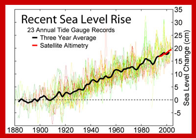
Measuring sea level, the level of the ocean surface, continually over many years allows scientists to calculate whether sea level is changing. This helps us to understand how much sea level rise is happening now because of global warming.

But measuring sea level is not easy. The sea is not level. If you tried to draw a flat line at the top of the ocean to mark the sea level you would find that there was water above the line in some places and below the line in other places. There are lots of small factors that can change the level of the ocean temporarily. Stand on a beach looking out at the ocean for a few hours and you will see the level of the ocean changing because of the tides. The ocean surface may not be a flat surface because of waves. The low atmospheric pressure of a storm can cause the ocean surface to bulge.

To even out the differences in sea level caused by waves, scientists use instruments called tide gauges. These are containers that block out the waves while measuring sea level. If the information is averaged over a year then variations like tides are evened out too. This average is called Mean Sea Level.

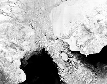
Satellites are also used to measure sea level. Sea surface height measurements have been recorded from satellites since 1992 by projects of NASA and the French Space Agency.

If there is a relative change in sea level, this means that the level of the ocean has changed with respect to the land. Relative changes in sea level are regional. For example, the land that New Orleans, Louisiana is built upon is sinking lower each year, a process called subsidence. Because the land is sinking, the sea level appears to be rising when it is measured relative to the land.

When the level of the oceans increases worldwide it is called a eustatic change in sea level. This is happening today as global warming melts glaciers and causes seawater to expand increasing the volume of water in the oceans. In New Orleans, the relative change in sea level is compounded by the eustatic change due to global warming. Eustatic sea level can also change over geologic time as plate tectonic motions change the shape of the oceans and how much water they can hold.

Last modified July 22, 2008 by Lisa Gardiner.

You might also be interested in:

Traveling Nitrogen Classroom Activity Kit

Check out our online store - minerals, fossils, books, activities, jewelry, and household items!...more

Climate Change and Sea Level Rise

The low-lying coast of Bangladesh in South Asia is home to millions of people, yet the amount of sea level rise predicted for the 21st Century is expected to change that, flooding homes with seawater and...more

Tidewater

Have you ever walked along a beach at low tide? Maybe you've had the opportunity to explore the world the sea water revealed when the water receded? Everyone likes to look for uncovered sea shells or the...more

Global Warming: Scientists Say Earth Is Heating Up

Earth’s climate is warming. During the 20th Century Earth’s average temperature rose 0.6° Celsius (1.1°F). Scientists are finding that the change in temperature has been causing other aspects of our planet...more

Glaciers and Ice Sheets

For a glacier to develop, the amount of snow that falls must be more than the amount of snow that melts each year. This means that glaciers are only found in places where a large amount of snow falls each...more

Plate Tectonics

Many forces cause the surface of the Earth to change over time. However, the largest force that changes our planet's surface is the movement of Earth's outer layer through the process of plate tectonics....more

Paleozoic "Sediment Curve" Provides New Tool for Tracking Sea-floor Sediment Movements

As the world looks for more energy, the oil industry will need more refined tools for discoveries in places where searches have never before taken place, geologists say. One such tool is a new sediment...more

Global Ice Age Climate Patterns Influenced by Bering Strait

In a vivid example of how a small geographic feature may have far-reaching impacts on climate, new research shows that water levels in the Bering Strait helped drive global climate patterns during ice...more

Windows to the Universe, a project of the National Earth Science Teachers Association, is sponsored in part is sponsored in part through grants from federal agencies (NASA and NOAA), and partnerships with affiliated organizations, including the American Geophysical Union, the Howard Hughes Medical Institute, the Earth System Information Partnership, the American Meteorological Society, the National Center for Science Education, and TERC. The American Geophysical Union and the American Geosciences Institute are Windows to the Universe Founding Partners. NESTA welcomes new Institutional Affiliates in support of our ongoing programs, as well as collaborations on new projects. Contact NESTA for more information. NASA ESIP NCSE HHMI AGU AGI AMS NOAA