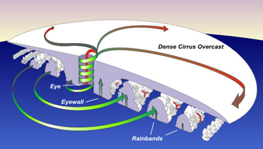
Cross section through a hurricane showing the locations of the eye, eyewall, and rainbands. Arrows show the direction of air movement within the storm. Air spirals upward at the eyewall and sinks in the center of the eye.
Click on image for full size
Courtesy of NOAA National Weather Service
The Eye of a Hurricane
At the center of a fierce tropical storm, there is a small area where the weather is calm, the sky is clear, and the winds are just light breezes. This area is called the eye of the storm.
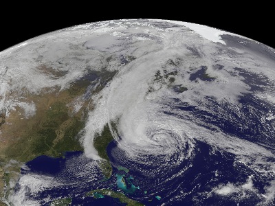
As a hurricane strengthens and wind speeds increase, an eye begins to form at the center of the storm. Usually this happens once winds reach about 80 mph. The eye is usually circular when viewed from above, and about 20 to 40 miles is diameter. It is roughly cylinder shape in cross section, extending through the center of the storm like a chimney. Air from above the storm sinks down in the center of the eye.
Surrounding the eye is the eyewall, which is the most violent part of a hurricane. The eyewall is a ring of dense cumulonimbus clouds thunderstorm clouds. There, the strongest winds in the hurricane are found and warm, moist air is pulled into the storm, rising along the eyewall where it cools and forms more cumulonimbus clouds.
Last modified March 12, 2009 by Lisa Gardiner.
You might also be interested in:

Wind is moving air. Warm air rises, and cool air comes in to take its place. This movement creates different pressures in the atmosphere which creates the winds around the globe. Since the Earth spins,
...more
As a strong hurricane heads towards the coast, people prepare - boarding up houses, packing the car, and evacuating. These storms can spell disaster for people in hurricane prone areas, so they are taken
...more
Cumulonimbus clouds belong to the Clouds with Vertical Growth group. They are generally known as thunderstorm clouds. A cumulonimbus cloud can grow up to 10km high. At this height, high winds will flatten
...more
Thunderstorms are one of the most thrilling and dangerous types of weather phenomena. Over 40,000 thunderstorms occur throughout the world each day. Thunderstorms form when very warm, moist air rises into
...more
Saturn's South Pole is very stormy. It is also surprisingly warm. A huge, hurricane-like storm is centered on the South Pole. Astronomers recently discovered that the pole is also warmer than any other
...more
At the center of a fierce tropical storm, there is a small area where the weather is calm, the sky is clear, and the winds are just light breezes. This area is called the eye of the storm. As a hurricane
...more
How many hurricanes will form this year? How strong will they be? While no one can say for sure, teams of scientists make predictions each year about the strength of the upcoming hurricane season. To make
...more


