
Name________________________
Background
Corals are marine organisms living within a very narrow set of habitat conditions. Changes in these conditions have affected coral reefs around the world. Your goal for this lesson will be to determine the biotic and abiotic factors needed by corals for survival. After determining these factors, you will explore the health of a selected coral reef, and present your findings at a Coral Reef Roundtable.
Activity Questions
What are corals and what biotic and abiotic factors are necessary for their survival? What is the current health status of the coral reefs found around the world?
Team Activity Tasks
Research information about corals
Learn how to use an online GIS mapping program
Use research information and GIS mapping information to create a presentation
Part 1: Corals
Using research materials provided by your teacher, fill in the tables below. Use your notebook if extra space is needed.
|
Features of Corals |
Information and Examples |
|
Body structure |
|
|
Skeleton |
|
|
Life cycle |
|
|
Feeding & feeding structures |
|
|
Relationship with zooxanthellae |
|
|
Other |
|
|
Abiotic Factors |
Information and Examples |
|
Sunlight |
|
|
Water Temperature
|
|
|
Water depth |
|
|
Ocean salinity & pH |
|
|
Clear and moving water |
|
|
Other |
|
|
Characteristics of Coral Ecosystems |
Information and Examples |
|
Role of corals |
|
|
Trophic levels present |
|
|
Ecological relationships present |
|
|
Other |
|
|
Benefits |
Description and Examples |
|
Ecological |
|
|
Economic |
|
|
Other |
|
|
Threats |
Description and Examples |
|
Changes in abiotic factors |
|
|
Disease |
|
|
Weather events |
|
|
Human threats |
|
|
Other |
|
Part 2: Reef GIS Data Interpretation
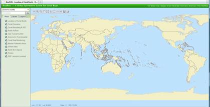
Now you are going to use Reef GIS (http://www.reefbase.org) to explore data from coral reefs around the world and from a selected location. Reef GIS is a Geographical Information System (GIS) program that allows users to display, explore, and analyze spatial data. Reef GIS incorporates a variety of recent scientific datasets for you to visualize and interpret.

Figure 1: Reef GIS front page. Map provided by ReefBase.
Open up the program and acquaint yourself to the tools and available data.
![]()
The toolbar controls allow you to do the following:
To go back to
your previous map click this button ![]() .
.
Zoom in and zoom
out click on one of these icons ![]() and then click on the map.
and then click on the map.
To pan around the
map click on this button ![]() .
.
To go back to the
original global view click this button ![]() .
.
To learn more
about a reef or to access the available satellite maps click this button ![]() and then
click on the map.
and then
click on the map.
To measure
distance click on this ruler icon ![]() , click on the map and then
stretch to measure.
, click on the map and then
stretch to measure.
To view
topographic map layer click this icon ![]() .
.
To show the place
names click this icon ![]() .
.
To save your map
click this icon ![]() and follow the steps listed.
and follow the steps listed.
To print your map
click on this icon ![]() and follow the steps listed.
and follow the steps listed.
The menu on the left of the screen is where you will go to acquire your maps. To visualize the data, first select a "Map" such as "Location of Coral Reefs," then select a "Layer" such as "Reef by Type," and then select "Legend" to learn more about the colors and to gather more information.
First at the global level, explore the Location of Coral Reefs map, then the Coral Diseases map, then Coral Bleaching and SST (sea surface temperature) map, and then the Reefs at Risk map. Be sure to click on the "Refresh Map" button to load the new maps. Use the toolbar to zoom in and out in order to gather additional information about coral reefs around the globe. Take note of the global distribution and any patterns in the data.
Next, repeat the above step but for a selected location. Share your chosen location with your teacher before proceeding to make sure there are no duplicate locations chosen within your classroom. Use the measuring tool and the information tool to learn more about the details of your coral reef. Save map images (JPEG) and satellite images for Part 3.
Part 3: Coral Reef Roundtable Presentation
Using all the information from this lesson, create a presentation in the format required by your teacher for the upcoming Coral Reef Roundtable. Keep in mind that others attending the Roundtable do not have any information about your chosen location. You and your team will want to be sure to include maps and images to support what you have to say. At the end of the Roundtable, your class will be summarizing the findings from all the teams into one report to be presented to the governments of each country involved. The leaders of the countries will not only learn more about the health of their coral reefs, but they will understand the importance of ensuring healthy coral reefs and that a global effort is required to do just that.