


Landsat Program |
|||
The View from 705 Kilometers Polar Orbit | |||
|---|---|---|---|
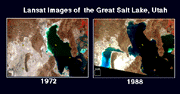 About the image: Shows the increase in the surface area of the Great Salt Lake in Utah between 1972 and 1988. Caused millions of dollars in damage due to flooding. | 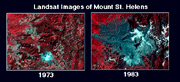 About the image: Mount St. Helens in 1973 (7 years before its 1980 eruption) and in 1983 (3 years after the eruption). The grayish blue areas are ash, mudslides and muddy rivers. |
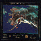 Scenes of Alaska from 1978 pieced together into one image | |
 Landsat image of Los Angeles, CA in 1987. San Gabriel mountains rise up at the top of the image. |
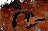 Landat image of the Great Lakes in 1987 |
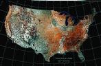 Mosaic of the U. S. taken from Landsat images between 1984 and 1988 | |
Data available from the U.S. Geological Survey, EROS Data Center, Sioux Falls, SD, custserv@edcmail.cr.usgs.gov, telephone 605-594-6151.
Other interesting Landsat image archives: Earthshots and Webglis and the Special Images Archive at the USGS (U. S. Geological Survey).
Last modified prior to September, 2000 by the Windows Team
The source of this material is Windows to the Universe, at http://windows2universe.org/ from the National Earth Science Teachers Association (NESTA). The Website was developed in part with the support of UCAR and NCAR, where it resided from 2000 - 2010. © 2010 National Earth Science Teachers Association. Windows to the Universe® is a registered trademark of NESTA. All Rights Reserved. Site policies and disclaimer.