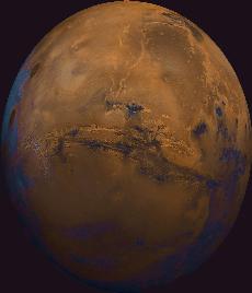
A map of the surface of Mars, showing where some volcanoes are located.
Click on image for full size
Image from: NASA
Martian Volcanoes
On this map of Mars, the lightly cratered Tharsis Ridge is shown, as well as the heavily cratered Martian highlands (near the bottom of the picture), and Valles Marineris to the right. The volcanoes are the yellow and red dots in the sea of blue in this image.
The Tharsis Ridge is the home of several of the Martian volcanoes, including Olympus Mons. Olympus Mons is the leftmost volcano in the image. The three large volcanoes which accompany Olympus Mons on the Tharsis Ridge are Arsia Mons, Pavonis Mons, and Ascraeus Mons. Measurements returned by Mars Global surveyor demonstrate the very large size of these volcanoes. Other volcanos named Tharsis Tholus, Ceraunius Tholus, Elysium Mons, and Albov Tholus are found in the right-hand side of the large topographic
map of Mars, as well as the very large version of the map to the left.
These volcanoes came into being early in Martian history.
You might also be interested in:
Next to the Tharsis Ridge is Valles Marineris, a very long canyon of Mars. As can be seen in the image, many huge ancient rivers extend toward the top of the image. The three Tharsis volcanoes (dark red
...more
The largest volcano in the solar system is Olympus Mons, shown in the image to the left. Olympus Mons is three times as high as the largest mountain on Earth, Mt. Everest, and is as wide as the entire
...more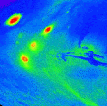
On this map of Mars, the lightly cratered Tharsis Ridge is shown, as well as the heavily cratered Martian highlands (near the bottom of the picture), and Valles Marineris to the right. The volcanoes are
...more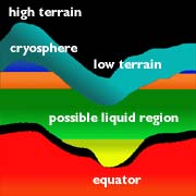
On Mars, the water is trapped, frozen, within the ground. Nevertheless, there is evidence for running water on Mars. When the water is melted and released to the surface, it will run from higher ground
...moreThe drawing shows the depth at which water may be frozen into the ground. To have water running on the surface of Mars, this water region must be near to the surface. This may have happened at various
...more
Separate from the Martian outflow channels, or the river valleys, are large Martian lakes (600 km, or ~1000 miles across) which once were part of a flood.
...more
This picture shows fog on Mars. More fog has been seen in images returned by Mars Global Surveyor of the south polar region of Mars. Martian fog may have a little bit of acid mixed in with the water drops.
...more
The orbit of Mars is very oval shaped. The orbit is much more oval shaped than the Earth's orbit. This means that the climate of Mars can change drastically between warm and cold.
...more


