Click on image for full size
Windows to the Universe original image
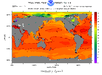
Temperature of Ocean Water
Most of the solar radiation (light and heat) that hits the ocean is absorbed in the first few tens of meters of water. Waves and turbulence mix this heat downward quickly. The surface layer of the ocean is well mixed from the top to the bottom of that layer. The temperature of the surface waters (the mixed layer) varies mainly with latitude. The polar seas (high latitude) can be as cold as -2 degrees Celsius (28.4 degrees Fahrenheit) while the Persian Gulf (low latitude) can be as warm as 36 degrees Celsius (96.8 degrees Fahrenheit). The average temperature of the ocean surface waters is about 17 degrees Celsius (62.6 degrees Fahrenheit).
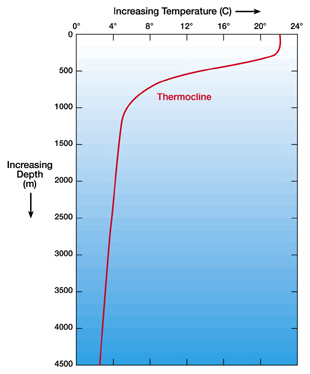
There is a boundary between surface waters of the ocean and deeper layers that are not well mixed. The boundary usually begins around 100-400 meters and extends several hundred of meters downward from there. This boundary region, where there is a rapid decrease of temperature, is called the thermocline. 90 % of the total volume of ocean is found below the thermocline in the deep ocean. Here, temperatures approach 0 degrees Celsius. So even though surface waters can be a comfortable 20 degrees Celsius (good for swimming in!), the majority of our ocean water has a temperature between 0-3 degrees Celsius (32-37.5 degrees Fahrenheit).
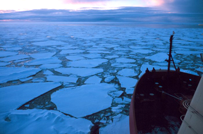
The density of ocean water continuously increases with decreasing temperature until the water freezes. Ocean water, with an average salinity of 35 psu, freezes at -1.94 degrees Celsius (28.5 degrees Fahrenheit). At very high latitudes, ocean water can reach these low temperatures and freeze. Dissolved salts in the water tend to be rejected by the forming ice so that sea ice is only about 1 % salt. An interesting tidbit for those of you interested in survival tactics - because of the lessened amount of salt, melted sea ice would be fit to drink even if sea water is not! Sea ice formation at high latitudes ultimately drives circulation of the deep waters of the ocean.
At the surface of the ocean, thermometers placed on buoys can take temperature measurements. In the last decade, the Argo program has taken on the task of monitoring the state of ocean surface waters across the globe. The Argo program deploys floats that measure salinity and temperature throughout the surface layer of the ocean. Over 3,000 free-drifting floats have been deployed all over the ocean and each float is programmed to sink 2,000 meters down, drifting at that depth for about 10 days. The float then makes its way to the surface measuring temperature and salinity the whole time. Data is transmitted to a satellite once the float reaches the surface, so that scientists and the public have access to the state of the ocean within hours of the data collection. At a greater depth in the water, in situ measurements are often made with a CTD instrument (CTD = conductivity, temperature, depth), where the instrument is placed in the ocean water from a ship or a platform. These instruments are used by the Bermuda Institute of Ocean Sciences (BIOS), where they have been tracking ocean measurements like temperature, salinity and oxygen concentrations for over 55 years.
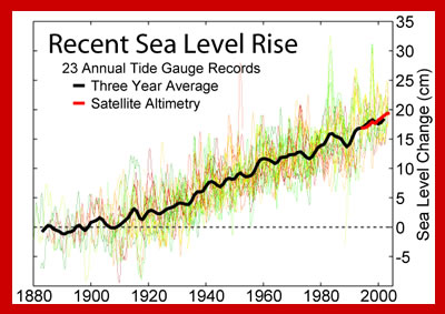
The Argos and BIOS program have both published results that confirm that the ocean is warming. Surface water temperatures obviously change from season to season and year to year, but the whole ocean has warmed about 0.1 degree Fahrenheit (0.055 degree Celsius) in the past 30-50 years. This may not seem like much of a temperature change, but it is quite significant. Think about a pot of water heating on a stove. A small pot of water will heat quickly, while a large pot of water at the same heat setting will heat very slowly. This is due to a difference in heat capacity. The ocean has an enormous heat capacity because of its large size, thus, it is like an enormous pot of water, and it takes a great amount of heat to warm the ocean. The fact that the ocean has warmed significantly in 30 to 50 years is remarkable and concerning.