Click on image for full size
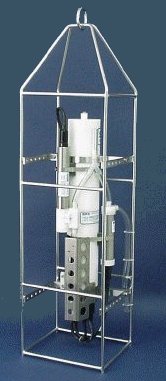
Sea-Bird Electronics, Inc.
CTD Instrument
In recent years, CTD instruments have become integral in measuring water characteristics such as salinity, temperature, pressure, depth and density. A CTD recorder, which stands for Conductivity-Temperature-Depth recorder, measures some of these characteristics directly and others indirectly.Over the years techniques for measuring water characteristics have changed drastically in method and in precision. Even Benjamin Franklin took temperature and salinity measurements of the Gulf Stream in the 18th century! But since the 1960's and 70's, the method of choice has been to use a CTD instument. CTD instruments are used "in situ" where the instrument is actually placed in the water it is measuring. As the CTD instrument is lowered through the water (or as it sits still at a given point), measurements of conductivity, temperature and depth are recorded continuously. General data acquisition for a CTD profiler is up to 24 Hz, which means that each parameter could be measured up to 24 times each second. This provides a very high resolution description of the water being tested.
CTD instruments measure three important parameters directly - conductivity, temperature and pressure. By measuring conductivity (how easily electric currents pass through the water sample being tested), scientists can get a measurement of that water sample's salinity. This is because electric current passes much more easily through water with a higher salt content. So if we know the conductivity of the water, we know how much salt is in the water. Salinity is measured in psu (practical salinity units). Accuracy of the measurement is generally better than 0.005 psu for a standard CTD profiler.
A CTD instrument usually uses a thermistor, a platinum thermometer, or a combination of these to measure the temperature of the water. Temperature as measured by a CTD instrument has an accuracy of greater than 0.005 degrees Celsius.
Finally, a CTD instrument measures pressure using either a strain gauge pressure monitor or a quartz crystal-based digital pressure gauge. Pressure is recorded in decibars, and since depth and pressure are directly related, a measurement in decibars can be converted to depth in meters. Conveniently, the pressure in "X" decibars is almost exactly equal to the pressure found at "X" meters of depth. For instance, at about 500 meters below the surface, the pressure is right around 500 dbars. The CTD instrument can measure pressure to within an error margin of about 1%.
Density of water is calculated from in situ measurements of conductivity (salinity), temperature and pressure. An equation called the equation of state of water relates the measurements so that density can be found if these other three values are known.
The conductivity, temperature and pressure measurements are recorded in digital form. They can be stored by the actual CTD instrument and transferred to a personal computer after the CTD has been brought out of the water or the transfer of data can happen continuously through a cord connected from the CTD instrument to a personal computer on ship or on dock. Often, other sensors are placed on CTD instruments so that dissolved oxygen, pH, turbidity and flourescence of the water can be measured. CTD profilers are sophisticated equipment, but they can be used in all sorts of situations. The HIGH TIDE project has high school students using a SeaBird Model SBE-19 CTD to measure water characteristics in Chesapeake Bay.