This photograph of a cumulonimbus cloud was taken near Fort Lupton, Colorado. You can see some towers growing in this cloud.
Click on image for full size
Photo courtesy of Gregory Thompson
Supercell Thunderstorms and Squall Lines
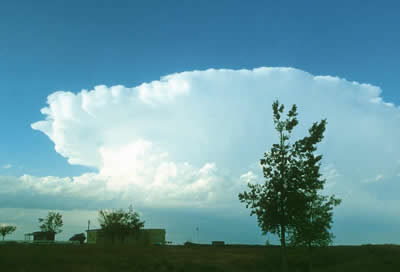
A supercell thunderstorm is a huge rotating thunderstorm. It can last for several hours as a single entity. These storms are the most likely to produce long-lasting tornadoes and baseball-sized hail. Tornadoes produced from supercell thunderstorms are usually the largest and most damaging because of the duration of the thunderstorms. Several tornadoes can come from one supercell thunderstorm.
Supercell thunderstorms are formed as a result of strong wind shear and a rapid increase in the speed and/or direction of the wind. There are two types of supercell thunderstorms. One is associated with high amounts of precipitation that creates downbursts, flash floods, and large hail. The other type is with low precipitation, developing tornadoes and large hail.
A squall line consists of several thunderstorms banded together in a line. They generally develop parallel to and ahead of an advancing front. Usually a squall line forms between a cold front and a warm front. A squall line can form from an individual storm that has split, which then helps to form a line of storms. Another way a squall line forms is on the south side of an existing thunderstorm.
There are two types of squall lines. One type is a line of cumulonimbus clouds that grow and decay; the other is a line of steady supercells. Squall lines can be just as severe as a supercell thunderstorm. A squall line can produce heavy precipitation and strong winds. Most of the precipitation in the United States is from a squall line. Typically the heaviest rain occurs on the east side of a squall line. Squall lines can extend over 600 miles (1000 km) when associated with thunderstorms.


Shop Windows to the Universe Science Store!
The
Fall 2009 issue of The Earth Scientist, which includes articles on student research into building design for earthquakes and a classroom lab on the composition of the Earth’s ancient atmosphere, is available in our
online store.
You might also be interested in:

Thunderstorms are one of the most thrilling and dangerous types of weather phenomena. Over 40,000 thunderstorms occur throughout the world each day. Thunderstorms form when very warm, moist air rises into
...more
Wind is moving air. Warm air rises, and cool air comes in to take its place. This movement creates different pressures in the atmosphere which creates the winds around the globe. Since the Earth spins,
...more
When a front passes over an area, it means a change in the weather. Many fronts cause weather events such as rain, thunderstorms, gusty winds, and tornadoes. As a cold front passes there may there may
...more
Cumulonimbus (weather symbol - Cb) clouds belong to the Clouds with Vertical Growth group. They are generally known as thunderstorm clouds. A cumulonimbus cloud can grow to such heights that it actually
...more
Rain is precipitation that falls to the Earth in drops of 5mm or greater in diameter according to the US National Weather Service. Virga is rain that evaporates before reaching the ground. Raindrops form
...more
Most tornadoes form in a part of a supercell thunderstorm called a mesocyclone. The mesocyclone draws energy into the storm so it can last for hours. Scientists aren't sure why, but some can create tornadoes.
...more
Have you ever tried to balance a long stick on your hand? Hard, isn't it? That's because the stick is part of an unstable system. If the wind pushes the stick a little bit, it will keep going in that direction.
...more