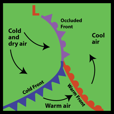
Weather map showing an occluded front
Click on image for full size
Windows to the Universe image by Lisa Gardiner
Occluded Fronts
Sometimes a cold front follows right behind a warm front. A warm air mass pushes into a colder air mass (the warm front) and then another cold air mass pushes into the warm air mass (the cold front). Because cold fronts move faster, the cold front is likely to overtake the warm front. This is known as an occluded front.
At an occluded front, the cold air mass from the cold front meets the cool air that was ahead of the warm front. The warm air rises as these air masses come together. Occluded fronts usually form around areas of low atmospheric pressure.
There is often precipitation along an occluded front from cumulonimbus or nimbostratus clouds. Wind changes direction as the front passes and the temperature changes too. The temperature may warm or cool. After the front passes, the sky is usually clearer and the air is drier.
On a weather map, like the one on the left, an occluded front looks like a purple line with half triangles and half semicircles along it pointing in the direction that the front is moving. It ends at a low pressure area shown with a large L on the map, and at the other end connects to cold and warm fronts.
Last modified August 12, 2009 by Lisa Gardiner.
You might also be interested in:
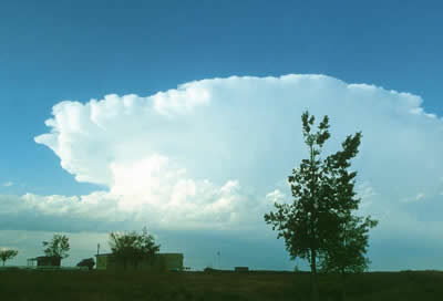
Cumulonimbus clouds belong to the Clouds with Vertical Growth group. They are generally known as thunderstorm clouds. A cumulonimbus cloud can grow up to 10km high. At this height, high winds will flatten
...more
Nimbostratus clouds belong to the Low Cloud (surface to 2000m up) group. They are dark gray with a ragged base. Nimbostratus clouds are associated with continuous rain or snow. Sometimes they cover the
...more
Wind is moving air. Warm air rises, and cool air comes in to take its place. This movement creates different pressures in the atmosphere which creates the winds around the globe. Since the Earth spins,
...more
When a front passes over an area, it means a change in the weather. Many fronts cause weather events such as rain, thunderstorms, gusty winds, and tornadoes. At a cold front passes there may there may
...more
There are two main types of thunderstorms: ordinary and severe. Ordinary thunderstorms are the common summer storm. Ordinary thunderstorms last about one hour. The precipitation associated with them is
...more
A supercell thunderstorm is a huge rotating thunderstorm. It can last for several hours as a single storm. These storms are the most likely to produce long-lasting tornadoes and baseball-sized hail. Tornadoes
...more
Lightning is the most spectacular element of a thunderstorm. In fact it is how thunderstorms got their name. Wait a minute, what does thunder have to do with lightning? Well, lightning causes thunder.
...more