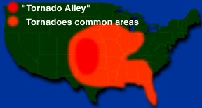
This map shows where most tornadoes form in the United States. The red
area is known as "Tornado Alley". Most of the tornadoes in the southern
U.S. near the Gulf of Mexico are formed by hurricanes
Click on image for full size
Click on image for full size
What is "Tornado Alley"?
A section of the Great Plains in the central part of the United States is called "Tornado Alley". This is because more tornadoes form here than any other part of the country. The plains are flat which allows cold polar air from Canada to meet warm tropical air from the Gulf of Mexico. Storm chasers go Tornado Alley looking for tornadoes because there are so many that form there.
Last modified April 29, 2016 by Jennifer Bergman.