Click on image for full size
National Weather Service Forecast Office of Topeka, KS
Sleet and Freezing Rain
Sleet forms when a partially melted snowflake or raindrop turns back into ice as it is falling through the air. Sleet starts out in the clouds as a snowflake or a raindrop. If it starts out as a snowflake, this means the layer it starts out in has a below freezing temperature; if it starts out as a raindrop then the first layer has an above freezing temperature. As the snowflake or raindrop falls towards the ground, it then moves through a warmer above freezing layer. This layer causes the snowflake to start to melt. Next the raindrop and the melted snowflake travel through a colder layer which is below freezing; this last layer causes the raindrop to freeze and the melted snowflake to refreeze. Sleet is usually tiny clear ice pellets that bounce when they hit the ground. An ice pellet is about 0.2 inches (5mm) or less, which is smaller than hail.
Freezing Rain happens when raindrops fall in liquid form and immediately freeze as they hit a cold surface. The process for freezing rain is similar to the process for sleet, except that freezing rain goes through a deeper layer of above freezing temperatures, allowing the snowflake to melt even further. The last layer the raindrop and melted snowflake travel through is rather small, unlike the last layer sleet travels through. This small layer causes the raindrops to become extremely cold. In this case, the ground level will have been below freezing for at least few hours if not several days. Freezing drizzle is similar to freezing rain but is much smaller and always starts out as a raindrop.
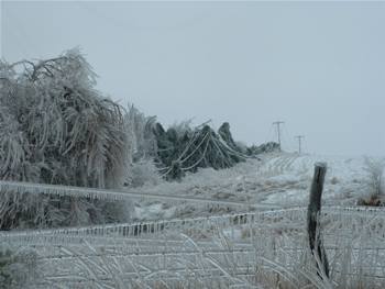
Freezing rain causes highways or roadways to be like ice skating rinks for automobiles. Since freezing rain freezes on contact with a surface, over time the amount of ice on an object increases. This can cause extensive damage to trees and power lines because the weight of the ice is too heavy for these objects. In January 1998 an ice storm or freezing rain storm hit northern New England and Canada and left millions of people without power in their homes.


