Current Events

  • Irish Chronicles Document Links Between Volcanoes and Weather
    A study of over 40,000 written entries in Irish Annals and ice core measurements shows a strong corr...Read more

    x

    Irish Chronicles Document Links Between Volcanoes and Weather

    A study of over 40,000 written entries in Irish Annals and ice core measurements shows a strong correlation between the occurrence of volcanic eruptions and extreme cold weather in Ireland over a 1200 year period. Data analyzed in this study cover the period from 431 to 1649, during which time up to 48 volcanic eruptions are identified in Greenland ice core records through deposition of volcanic sulfate in annual layers of ice. You can find the study (open access), published on 6 June 2013 in IOP Publishing's journal Environmental Research Letters, at http://iopscience.iop.org/1748-9326/8/2/024035/article. Find out more about how volcanoes can influence climate.
  • EF-5 Tornado in El Reno, Oklahoma Widest Ever Recorded in US
    The EF-5 tornado that hit El Reno, Oklahoma on May 31st was the widest ever recorded in the US, acco...Read more

    x

    EF-5 Tornado in El Reno, Oklahoma Widest Ever Recorded in US

    The EF-5 tornado that hit El Reno, Oklahoma on May 31st was the widest ever recorded in the US, according to the National Weather Service in Norman Oklahoma. The tornado, which remained on the ground for 40 minutes and reached 2.6 miles across (4.2 km), took the lives of 18 people including storm chasers Tim Samaras, Paul Samaras and Carl Young. For more information on the tornado, visit http://ow.ly/i/2hfDG.
  • Atmospheric CO2 Level Tops 400 ppm
    During the week of May 13th, the CO2 level at the Mauna Loa Observatory in Hawaii topped 400 ppm rep...Read more

    x

    Atmospheric CO2 Level Tops 400 ppm

    During the week of May 13th, the CO2 level at the Mauna Loa Observatory in Hawaii topped 400 ppm repeatedly. Daily levels of CO2 can vary due to weather, and there are seasonal trends as well. The level of atmospheric greenhouse gases continues to increase, now over 120 ppm since the Industrial Revolution began. For more on the Keeling Curve, see http://keelingcurve.ucsd.edu/. Find out more about greenhouse gases and warming.
This is a mosaic of the caloris basin and its surrounding area. The Caloris Basin is closest to the sun when Mercury is at the closest point in its orbit to the sun.
Click on image for full size
NASA

The Caloris Basin

The Caloris Basin is the largest feature on the surface of Mercury. This crater was formed by the impact of a large meteorite in the early formation of the solar system. We only know what half of the crater looks like, because the other half was in darkness when Mariner 10 flew by the planet. Surrounding the impact site are concentric ridges within relatively smooth plains probably brought about by renewed volcanic activity which started after the impact. On the other side of the planet, directly across from the basin, is a region initially described as the "weird" terrain, where a chaotic mix of hills and fractures is present. This may have been produced in response to shock waves which traveled to this point on the surface following the Caloris Basin impact.

Shop Windows to the Universe Science Store!

Our online store includes issues of NESTA's quarterly journal, The Earth Scientist, full of classroom activities on different topics in Earth and space science, as well as books on science education!

Windows to the Universe Community

News

Opportunities

You might also be interested in:

Science, Evolution, and Creationism

How did life evolve on Earth? The answer to this question can help us understand our past and prepare for our future. Although evolution provides credible and reliable answers, polls show that many people turn away from science, seeking other explanations with which they are more comfortable....more

Mercury's Craters

A wide variety of craters ranging in size from 100 meters to 1300 km across can be seen in the Mariner 10 images of Mercury's surface. These include: (1) craters in young terrain, (2) double craters,...more

Surface Features of Mercury

The surface of Mercury has numerous interesting features, including a variety of craters, ridges, and terrains ranging from heavily cratered to nearly crater free. These features, and their location across...more

Surface of Mercury

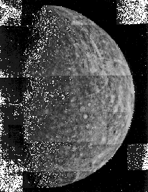
Images of the surface of Mercury obtained by Mariner 10 showed a planet covered with craters, looking very much like the Earth's Moon. During its three passes by the planet, Mariner 10 took pictures of...more

The Caloris Basin

The Caloris Basin is the largest feature on the surface of Mercury. This crater was formed by the impact of a large meteorite in the early formation of the solar system. We only know what half of the...more

Wrinkle Ridges

Wrinkle ridges on the surface of Mercury are thought to have been caused by the shrinking of the surface following the cooling and shrinking of the core of the planet. As the core cooled and shrank, the...more

Evolution of Mercury

Mercury, like the other planets, is believed to have formed in the earliest stage of the evolution of the solar system as dust came together to form even larger clumps and eventually small planets or...more

Mercury's Interior and Surface

Mercury, the innermost planet of the solar system, is a little bigger than the Earth's Moon. The surface of the planet is covered with craters, like the Moon, but temperatures there can reach over 80...more

Shop Windows to the Universe

Check out the fun Earth science related bumper stickers in our online store! Express yourself!

Windows to the Universe, a project of the National Earth Science Teachers Association, is sponsored in part by the National Science Foundation and NASA, our Founding Partners (the American Geophysical Union and American Geosciences Institute) as well as through Institutional, Contributing, and Affiliate Partners, individual memberships and generous donors. Thank you for your support! NASA AGU AGI NSF