Mars Image List
Here is a movie of mars rotating.

This is an image of Mars taken by the Hubble Space Telescope in February 1995. (Courtesy of STScI and NASA)
(35K JPG)

This is an image of Mars. (Courtesy of NASA/JPL)
(236K GIF)

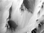
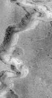
This is an image of the South Candor Chasma. (Courtesy of NASA/JPL)
(146K JPG)

This is an image of the Hellas region. (Courtesy of USGS)
(61K GIF)

This is another image of Mars of the Schiaparelli region. (Courtesy of NASA/JPL)
(258K GIF)
This image shows a portion of the Schiaparelli region on Mars. From Mars Global Surveyor. (Courtesy Malin Space Science Systems)

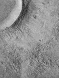
This is an image of a hill in the northern plains called the Face on Mars .
(308K GIF)
Craters
This is an image of the Sinus Sabaus and Deucalionis Regio portion of Mars. The lower right crater is Flaugergues and the double crater to the lower left is Wislicenus. This image was taken by the Mariner 6 in 1969. In this image can be found many siun ous features suggestive of Martian rivers, and even outflow from a central plain. Viewing of this image in high resolution is recommended. (Courtesy of NASA/JPL)
(282K GIF)
This is image shows flow ejecta of a crater on Icaria Planum. (Courtesy Malin Space Science Systems - 153K)
Martian Hemispheres

This is a mosaic of Mars of the Syrtis Major region. (Courtesy of USGS)
(288K JPG)

This is a mosaic of the Schiaparelli region on Mars. (Courtesy of USGS)
(92K GIF)

This is a mosaic of the Valles Marineris hemisphere on Mars. The Valles Marineris is a large canyon system. (Courtesy of USGS)
(82K GIF)

This is a larger image of the same thing. (Courtesy of NASA)
(242K JPG)
Valles Marineris

This is a false color image of the Valles Marineris. (Courtesy of NASA)
(213K GIF)

This is a close-up image of the Valles Marineris. (Courtesy of NASA)
(121K JPG)

This is a false color image of the Valles Marineris showing possibility of erosion. (Courtesy of NASA)
(243K GIF)
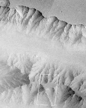
Excerpt from U.S. Geological
Survey Mars Digital Image Mosaic, reproduced at a scale of 230
meters/pixel. The outlines of other images are shown as white boxes. (Courtesy Malin Space Science Systems )
Mosaic of Viking Orbiter 1 frames 428A62,
428A63, and 428A65, reproduced at a scale of 80 meters/pixel
or 40 meters/pixel full resolution. The outline of the next image is shown as a white box. (Courtesy Malin Space Science Systems )
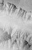
This picture
of the Martian surface was obtained in the early
evening of January 1, 1998 by the Mars Orbiter Camera (MOC),
shortly after the Mars Global Surveyor spacecraft began it's
80th orbit. Seen in this view are a plateau and surrounding
steep slopes within the Valles Marineris. (Courtesy Malin Space Science Systems )
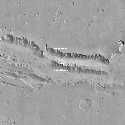
This is an image of West Tithonium Chasma, on the western edge of Valles Marineris, taken by Mars Global Surveyor. Note the geologic features in the image. (Courtesy Malin Space Science Systems )
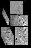
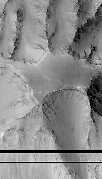
This image shows a portion of the Nirgal Vallis region on Mars, a portion of Valles Marineris. From Mars Global Surveyor. (Courtesy Malin Space Science Systems)
Polar Caps
These are Mariner 7 images of Mars taken in August 1969. (Courtesy of NASA/JPL)
(106K GIF)
This image shows a mosaic of the south polar cap of Mars. In the lower left corner is a global view of the polar caps. (Courtesy NASA/JPL)

This is a false color image of the south pole of mars showing the polar cap. (Courtesy of NASA)
(146K GIF)

Another image of the south pole. (Courtesy of NASA)
(100K JPG)
This is an image of layered terrain in the south polar region, and a potential Mars '98 landingsite. From Mars Global Surveyor. (Courtesy Malin Space Science Systems )

Ice cliffs at the North polar region. (Courtesy NASA/JPL)
Mountains and Volcanoes

This color image shows the caldera of Olympus Mons, the highest volcano on Mars. (Courtesy of NASA)
(327K GIF)
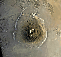
This is a mosaic of Olympus Mons. (Courtesy of NASA)
(149K GIF)

This is a image of the Tharsis Montes volcano region showing Olympus Mons and a few other volcanoes in red/yellow. (Courtesy of NASA)
(49K GIF)

This is an image of the northern hemisphere from the Mars Orbiter Laser
Altimiter. It shows the northern plains, western Elysium volcanic
province, and ancient southern highlands. (Courtesy of NASA)
(34K
JPEG)

This is an image of the Pavonis Mons summit on Mars.
(94K GIF)

This is a topographic contour map of the Gusev Crater. (Courtesy of NASA/JPL)
(196K GIF)

This is a false color image of the caldera collapse pit at the summit of one of the large volcanos on the Tharsis plateau. (Courtesy of NASA)
(197K GIF)
Moons

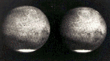
This is an image of Mars' satellites. Phobos is on the right and Deimos on the left. (Courtesy of NASA/JPL)
(57K GIF)
Soils

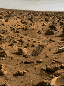
Soils of Mars from Mars Pathfinder. (Courtesy JPL/NASA)

Soils of Mars from Mars Pathfinder. (Courtesy JPL/NASA)

Soil of Mars at the Mermaid dune. [There is no large version of this image]. (Courtesy JPL/NASA)

This is an image of the Viking Lander 2 site on Mars. (Courtesy of Mary A. Dale-Bannister, Washington University in St. Louis)
(643K JPG)

This is a photograph of the Viking Lander 1 site of the surface and atmosphere of Mars. (Courtesy of NASA/JPL)
(212K GIF)
This is an image of the Viking Lander 2 site. (Courtesy of NASA)
(142K GIF)

This is another image of the Viking Lander site. (Courtesy of NASA)
(66K JPG)

This is a mosaic taken by Viking Lander 1 made in 1977. (Courtesy of NASA/JPL)
(624K GIF)
Drifts

Wind drifts at the Mars Pathfinder landing site. (Courtesy JPL/NASA)

Wind drifts at the Mars Pathfinder landing site. (Courtesy JPL/NASA)

Wind drifts at the Mars Pathfinder landing site, & Souffle rock. (Courtesy JPL/NASA)

Wind drifts at the *Viking I* landing site (labeled). (Courtesy JPL/NASA)
Sanddunes

Sanddunes at the Mars Pathfinder landing site. (Courtesy JPL/NASA)

The Mermaid dune from Mars Pathfinder. (Courtesy JPL/NASA)

Jenkins dune from Mars Pathfinder. (Courtesy JPL/NASA)

Sand dune images from the *Viking I landing site*, Chryse Planitia Basin (check the large topographic map of Mars). (Courtesy NASA/JPL)

Dune fields near the south pole. (Courtesy JPL/NASA)
Water?
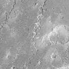
Viking Orbiter 1 frame 897A32, reproduced at a scale of 150 meters/pixel. The outline of the next image is shown as a white box. (Courtesy Malin Space Science Systems )
The canyon of Nanedi
Vallis, one of the Martian valley systems cutting through
cratered plains in the Xanthe Terra region of Mars. (Courtesy Malin Space Science Systems )
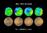
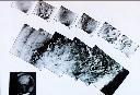
This graph shows proof of the existence of clouds of water on Mars. The sequence shows the water clouds moving across the face of Mars. From Mars Global Surveyor. (Courtesy NASA/JPL)
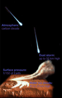
The Martian Atmosphere

This is a local dust storm on Mars located near the edge of the south polar cap. (Courtesy Calvin J. Hamilton, LPI, and NASA)
(158K GIF)

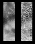
Clouds of Mars from Mars Pathfinder. (Courtesy JPL/NASA)

Clouds of Mars from Mars Pathfinder. (Courtesy JPL/NASA)

Clouds of Mars from Mars Pathfinder. (Courtesy JPL/NASA)

Clouds of Mars from Mars Pathfinder. (Courtesy JPL/NASA)

Viking I sunset. (Courtesy NASA/JPL)

Sunset of Mars from Mars Pathfinder. (Courtesy JPL/NASA)

Sunset of Mars from Mars Pathfinder. (Courtesy JPL/NASA)

Sunset of Mars from Mars Pathfinder. (Courtesy JPL/NASA)
Martian Meteorites

This is an image of a martian meteorite. (Courtesy of NASA)
(217K GIF)
Global Maps

This is a sinusoidal projection of the topography of Mars. (Courtesy of NASA)
(83K JPG)

This is a Digital Image Model of Mars. (Courtesy of NASA)
(163K JPG)

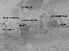
An annotated Map of Mars. (Courtesy of NASA)
(163K JPG)
This is a labeled map showing regions imaged by Mars Global Surveyor early in the mission. Viewing of this image in high resolution is recommended. (Courtesy Malin Space Science Systems )
Go back to Saturn,
Pluto,
Mercury,
Jupiter,
Neptune,
Venus,
Moon,
Asteroids,
Comets,
Earth,
Sun,
Missions,
Uranus,
Astrophysical Objects,
Mariner Images,
Viking Images,
Mars Pathfinder Images,
Mars Global
Surveyor Images