Viking Image List


Viking I Landing site - Chyrse Planitia


An image of Mars from the Viking I lander. (Courtesy NASA/JPL)


Soil sampler with completed trench, from the Viking I lander. (Courtesy NASA/JPL)


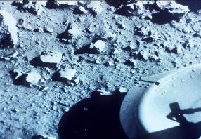
A panorama of the Martian landscape from the Viking lander. This region is called Chryse Planitia. (Courtesy NASA/JPL)


An image of Mars from the Viking lander. (Courtesy NASA/JPL)


A panorama of the Martian landscape from the Viking lander, complete with data screen. (Courtesy NASA/JPL)


Sand dunes in the Chryse Planitia Basin, from the Viking I lander. (Courtesy NASA/JPL)


Winddrifts at the Viking I landing site. Drifts such as these were also studied by the Mars Pathfinder mission. (Courtesy NASA/JPL)


Viking I sunset. (Courtesy NASA/JPL)


Viking II Landing site - Utopia Planitia


An image of Mars from the Viking lander. (Courtesy NASA/JPL)


An image of the Viking II lander. The symbol of the American bicentennial celebration from 1976 can be seen on the lander. (Courtesy NASA/JPL)


An image of Mars from the Viking II lander. (Courtesy NASA/JPL)


An image of Mars from the Viking II lander. (Courtesy NASA/JPL)


Viking Orbiter results


An image of Mangala Valles from the Viking orbiter. Viewing of this image in high resolution is recommended. (Courtesy NASA/JPL)


Ice cliffs at the North polar region. Viewing of this image in high resolution is recommended. (Courtesy NASA/JPL)


Valles Marineris from the Viking orbiter. Viewing of this image in high resolution is recommended. (Courtesy NASA/JPL)


This is a false color image of the Valles Marineris showing possibility of erosion. (Courtesy of NASA)
(243K GIF)


This is a false color image of the Valles Marineris. (Courtesy of NASA)
(213K GIF)


This is an image of the South Candor Chasma. Viewing of this image in high resolution is recommended. (Courtesy of NASA/JPL)
(146K JPG)


This is a false color image of the caldera collapse pit at the summit of one of the large volcanos on the Tharsis plateau. Viewing of this image in high resolution is recommended. (Courtesy of NASA)
(197K GIF)


Go back to Mars, Pluto, Mercury, Saturn, Neptune, Venus, Moon, Jupiter, Asteroids, Comets, Sun, Missions, Uranus, Astrophysical Objects, Mariner Images, Mars Pathfinder Images, Mars Global Surveyor Images

You might also be interested in:

Cool It! Game

Check out our online store - minerals, fossils, books, activities, jewelry, and household items!...more

The Viking Missions

The Viking I and Viking 2 missions were designed to both orbit Mars and land and make exploratory observations on the planet's surface. At this stage in the history of the exploration of Mars, scientists...more

Mars Odyssey

The Mars Odyssey was launched April 7, 2001, from Florida. After a six-month, 285 million-mile journey, the Odyssey arrived at Mars on October 24, 2001. The Odyssey is in its aerobraking phase right now....more

Mars 2005

The Mars 2005 mission is still in the planning stages. It is set to launch in the year 2005. ...more

Aerobraking

The Mars Global Surveyor reached Mars in September of 1997. But it didn't make it into its final mapping orbit until February 1999. What took so long? Surveyor needed to reach a near-circular, low-altitude...more

Mars Global Surveyor Measures Olympus Mons

Mars Global Surveyor carries an instrument which measures the heights of things. This instrument is called an altimeter, or "altitude-meter". The graph to the left shows the results returned from Mars...more

Mars Global Surveyor Measures Martian Global Hemispheres

Mars Global Surveyor carries an instrument which measures the heights of things. This instrument is called an altimeter, or "altitude-meter". The picture to the left shows Mars Global Surveyor's measurement...more

Mars Global Surveyor Measures Volcano Altitudes

Mars Global Surveyor carries an instrument which measures the heights of things. This instrument is called an altimeter, or "altitude-meter". The picture to the left shows the results returned from Mars...more

Windows to the Universe, a project of the National Earth Science Teachers Association, is sponsored in part is sponsored in part through grants from federal agencies (NASA and NOAA), and partnerships with affiliated organizations, including the American Geophysical Union, the Howard Hughes Medical Institute, the Earth System Information Partnership, the American Meteorological Society, the National Center for Science Education, and TERC. The American Geophysical Union and the American Geosciences Institute are Windows to the Universe Founding Partners. NESTA welcomes new Institutional Affiliates in support of our ongoing programs, as well as collaborations on new projects. Contact NESTA for more information. NASA ESIP NCSE HHMI AGU AGI AMS NOAA