Current Events

  • Irish Chronicles Document Links Between Volcanoes and Weather
    A study of over 40,000 written entries in Irish Annals and ice core measurements shows a strong corr...Read more

    x

    Irish Chronicles Document Links Between Volcanoes and Weather

    A study of over 40,000 written entries in Irish Annals and ice core measurements shows a strong correlation between the occurrence of volcanic eruptions and extreme cold weather in Ireland over a 1200 year period. Data analyzed in this study cover the period from 431 to 1649, during which time up to 48 volcanic eruptions are identified in Greenland ice core records through deposition of volcanic sulfate in annual layers of ice. You can find the study (open access), published on 6 June 2013 in IOP Publishing's journal Environmental Research Letters, at http://iopscience.iop.org/1748-9326/8/2/024035/article. Find out more about how volcanoes can influence climate.
  • EF-5 Tornado in El Reno, Oklahoma Widest Ever Recorded in US
    The EF-5 tornado that hit El Reno, Oklahoma on May 31st was the widest ever recorded in the US, acco...Read more

    x

    EF-5 Tornado in El Reno, Oklahoma Widest Ever Recorded in US

    The EF-5 tornado that hit El Reno, Oklahoma on May 31st was the widest ever recorded in the US, according to the National Weather Service in Norman Oklahoma. The tornado, which remained on the ground for 40 minutes and reached 2.6 miles across (4.2 km), took the lives of 18 people including storm chasers Tim Samaras, Paul Samaras and Carl Young. For more information on the tornado, visit http://ow.ly/i/2hfDG.
  • Atmospheric CO2 Level Tops 400 ppm
    During the week of May 13th, the CO2 level at the Mauna Loa Observatory in Hawaii topped 400 ppm rep...Read more

    x

    Atmospheric CO2 Level Tops 400 ppm

    During the week of May 13th, the CO2 level at the Mauna Loa Observatory in Hawaii topped 400 ppm repeatedly. Daily levels of CO2 can vary due to weather, and there are seasonal trends as well. The level of atmospheric greenhouse gases continues to increase, now over 120 ppm since the Industrial Revolution began. For more on the Keeling Curve, see http://keelingcurve.ucsd.edu/. Find out more about greenhouse gases and warming.

Mars Odyssey Image List


The Mars Odyssey spacecraft


This is an artist's depiction of the Mars Surveyor 2001 Orbiter showing the Orbiter as it reached Mars. (Courtesy of NASA)


Images from the Mars Odyssey


This is the Mars Odyssey's first picture. It took this picture of the Earth and Moon on April 19th, 2001, in celebration of Earth day. The image was taken as part of the calibration process for the thermal emission imaging system, the camera system that is one of three science instrument packages on the spacecraft. (Courtesy of NASA/JPL)


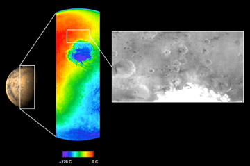
This image shows both a visible and a thermal infrared image taken by the thermal emission imaging system on NASA's 2001 Mars Odyssey spacecraft on November 2, 2001. The visible wavelength image, shown on the right in black and white, was obtained using one of the instrument's five visible filters. The spacecraft was approximately 22,000 kilometers (about 13,600 miles) above Mars looking down toward the south pole when this image was taken. The thermal infrared image, center, shows the temperature of the surface in color. The circular feature seen in blue is the extremely cold martian south polar ice cap. The instrument measured a temperature of minus 120 degrees Celsius (minus 184 degrees Fahrenheit) at this ice cap. (Courtesy of NASA/Jet Propulsion Laboratory/Arizona State University)


Go back to Mars, Pluto, Mercury, Saturn, Neptune, Venus, Moon, Jupiter, Asteroids, Comets, Sun, Missions, Uranus, Astrophysical Objects, Mariner Images, Viking Images, Mars Pathfinder Images


IMAGEMAP

Last modified November 26, 2001 by Jennifer Bergman.

Shop Windows to the Universe Science Store!

Our online store includes issues of NESTA's quarterly journal, The Earth Scientist, full of classroom activities on different topics in Earth and space science, ranging from seismology, rocks and minerals, oceanography, and Earth system science to astronomy!

Windows to the Universe Community

News

Opportunities

You might also be interested in:

Traveling Nitrogen Classroom Activity Kit

Check out our online store - minerals, fossils, books, activities, jewelry, and household items!...more

Mars Odyssey

The Mars Odyssey was launched April 7, 2001, from Florida. After a six-month, 285 million-mile journey, the Odyssey arrived at Mars on October 24, 2001. The Odyssey is in its aerobraking phase right now....more

Mars 2005

The Mars 2005 mission is still in the planning stages. It is set to launch in the year 2005. ...more

Aerobraking

The Mars Global Surveyor reached Mars in September of 1997. But it didn't make it into its final mapping orbit until February 1999. What took so long? Surveyor needed to reach a near-circular, low-altitude...more

Mars Global Surveyor Measures Olympus Mons

Mars Global Surveyor carries an instrument which measures the heights of things. This instrument is called an altimeter, or "altitude-meter". The graph to the left shows the results returned from Mars...more

Mars Global Surveyor Measures Martian Global Hemispheres

Mars Global Surveyor carries an instrument which measures the heights of things. This instrument is called an altimeter, or "altitude-meter". The picture to the left shows Mars Global Surveyor's measurement...more

Mars Global Surveyor Measures Volcano Altitudes

Mars Global Surveyor carries an instrument which measures the heights of things. This instrument is called an altimeter, or "altitude-meter". The picture to the left shows the results returned from Mars...more

Instruments of the Mars Global Surveyor Mission

It has been more than 30 years since America's first exploratory missions to Mars. Here are some of the instruments carried onboard Mars Global Surveyor (called MGS for short). Many of these instruments...more

Shop Windows to the Universe

With Explore the Planets, investigate the planets, their moons, and understand the processes that shape them. By G. Jeffrey Taylor, Ph.D. See our DVD collection.

Windows to the Universe, a project of the National Earth Science Teachers Association, is sponsored in part by the National Science Foundation and NASA, our Founding Partners (the American Geophysical Union and American Geosciences Institute) as well as through Institutional, Contributing, and Affiliate Partners, individual memberships and generous donors. Thank you for your support! NASA AGU AGI NSF