This is a picture of the Rover atop the Mermaid Dune.
Click on image for full size
JPL/NASA
The Mermaid Dune
During the Mars Pathfinder Rover's exploration of the Martian surface, it went over what scientists now call the "Mermaid Dune". The soil on top of Mermaid Dune seemed to be dark gray. However, when the Rover crossed the dune, it disturbed the soil and there was a dark red soil underneath. A picture of the disturbed soil is shown here.
There are many portions of Mars covered by sand dunes, including gaint sand dunes at the south polar region.
Study of these dunes and soils helps scientists understand the erosion of the Martian surface.
You might also be interested in:

Spinning the Rover's rear wheels was one way for scientists to test the soil of Mars. As the wheels dug into the surface, the Rover discovered that much of the ground is made of dust, possibly deposited
...more
The Mars Odyssey was launched April 7, 2001. After a six-month journey, the Odyssey arrived at Mars on October 24, 2001. The instruments onboard the Mars Odyssey will study the minerals on the surface
...more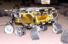
The Mars 2005 mission is still in the planning stages. It is set to launch in the year 2005.
...more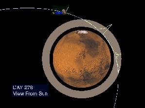
Aerobraking slowed the Mars Global Surveyor down when it reached Mars. Aerobraking also helped MGS to get into the right orbit for mapping the surface of Mars. Aerobraking means that the MGS flew through
...more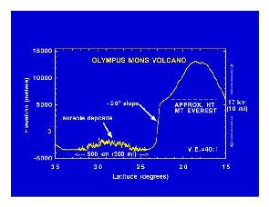
Mars Global Surveyor carries an instrument which measures the heights of things. This instrument is called an altimeter, or "altitude-meter". The graph to the left shows the results returned from Mars
...more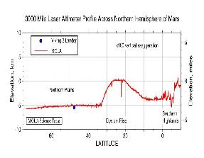
Mars Global Surveyor carries an instrument which measures the heights of things. The picture to the left shows Mars Global Surveyor's measurement of the size of the giant cliff which separates the southern
...more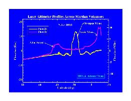
Mars Global Surveyor carries an instrument which measures the heights of things. The picture to the left shows the results returned from Mars Global Surveyor's measurement of the size of some of the Martian
...more


