

Earth Image List
Globe
Here are some movies
- earthro2.mpeg
- galapo.mpeg (galapagos islands)
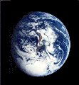
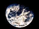
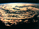
Image of the Earth.

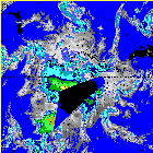
This is a picture of the Earth's magnetic field and the Van Allen Belts. The Van Allen Belts are two layers where the atomic particles are trapped and the magnetosphere is dense.
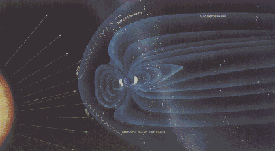
This is another image of the magnetosphere. Here you can see the interaction between the solar wind and the earth's magnetic field.
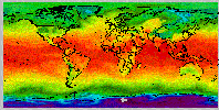
This infrared image of the Earth was taken by the GOES 6 satellite on September 21, 1986. A temperature threshold was used to isolate the clouds. The land and sea were separated and then the clouds, land and sea were separately colored and combined back together to produce this image. (Courtesy Rick Kohrs)

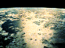
This photo was taken in December 1972 by the Apollo 17 crew. The spacecraft was traveling between the Earth and the Moon. The redish landmass is Africa and Saudi Arabia which is desert. The white is both clouds and the ice covering Antarctica. (Courtesy NASA/JPL)
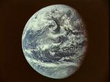
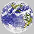
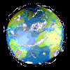
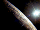
Image of Earth.

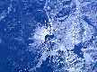
This image of the Earth was taken by the Galileo spacecraft at about 6:10 a.m. PST on December 11, 1990. The spacecraft was about 1.3 million miles from the Earth. South America is near the center of the picture, and the white, sunlit continent of Antarctica is below. Picturesque weather fronts are visible in the South Atlantic, lower right. (courtesy of NASA/JPL)
This is an image of the Earth's Western Hemisphere. (Courtesy of Aris Multimedia Entertainment, Inc. 1994)
This is a rendered image of Earth.
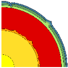
This image shows the divisions of the Earth's interior. Click on the
image to see labels. (Adapted from Beatty, 1990)
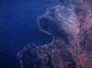
This is an image of Antarctica taken by Galileo on December 8, 1990. This is the first picture of the whole Antarctic continent taken nearly at once from space. Galileo was about 200,000 kilometers (125,000 miles) from Earth when the pictures were taken.
(Courtesy Calvin J. Hamilton, NASA/JPL)
This is an image of an Antarctic Surface Plot of weather.
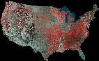
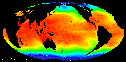
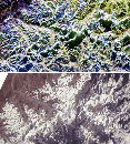
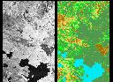
This United States is a mosaic prepared by using 16 images from the Advanced Very High Resolution Radiometer (AVHRR) sensors on the meteorological satellites NOAA-8 and NOAA-9. The images were taken between May 24, 1984 and May 14, 1986.
On false-color infrared mosaics, vegetation appears in red instead of green. The "redness" indicates vegetation density, type and whether growing on dry land or in a swamp. Grasslands appear light red, deciduous trees and croplands appear red, and coniferous forests appear dark red or maroon. Desert areas appear white and urban areas appear bluish green. Lakes, rivers and oceans appear in various shades of blue, dark blue for deep water and light blue for shallow or turbid water. (Courtesy USGS)

Lights of Earth. (Courtesy Defense Meteorological Satellite Program)
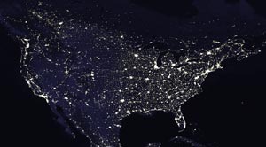
Lights of the contiguous United Sates of America. (Courtesy Defense Meteorological Satellite Program)
Image of clouds taken by the STS-63.
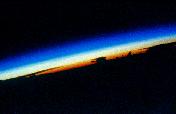
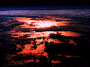
This is an image of the sunrise from space over the South China Sea. An astronaut would see something like this; clearly defined bands of color through the atmosphere as the sun rises. High-peaking cumulus clouds, topping out in anvil-head cirrus can beseen as black shadows against the sunlit horizon. The brightness of the colors in the atmosphere in this photograph is due to the amount of dust in the atmosphere. More dust is found in near the equator. There are various sources for such upper level dust. Many dust storms in Africa and ash clouds from major volcanic eruptions are two reasons. (Courtesy LPI/NASA)
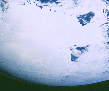
Clouds
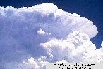
This is an image taken of cumulonimbus clouds in the atmosphere. (Courtesy of Aris Multimedia Entertainment, Inc. 1994)
This is a satellite image taken of clouds.
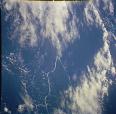
This is another satellite image taken of clouds.
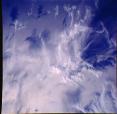
This is another satellite image taken of clouds.
This is an image of a supercell. This occurs when cumulonimbus clouds quickly develop into powerful thunderstorm clouds. (courtesty of Kevin Knupp, University of Illinois cloud catalog)
This is a picture of cirrus fall streaks which usually occur in good weather. They form when snowflakes and ice crystals fall from the high clouds. (courtesy of University of Illinois cloud catalog)
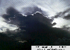
This is an image of a cumulonimbus cloud while the sun is setting behind it. (Courtesy of Ronald Holle, University of Illinois cloud catalog)

These are altocumulus clouds which appear to be puffy. (courtesy of Ronald Holle, University of Illinois cloud catalog)
Weather
This is an image of a Cyclonic Storm. (courtesy of Aris Multimedia Entertainment, Inc. 1994)
This is an image of a tropical storm.
(courtesy of Aris Multimedia Entertainment, Inc. 1994)

Lightning. (image courtesy of JPL)

Lightning. (image courtesy of JPL)
Maps
This is an example of what a current weather map looks like.
This is another example of what a current weather map looks like.
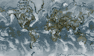
This is a rectangular map projection of the world

This is a sinusoidal map projection of the world.
This is an image of what a current minimum temperature map would look like.
This is an image of the globe where the continents black.
Craters
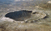
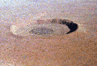
This is the Barringer Meteor Crater in Arizona. The diameter is 1.2 kilomters, and it is 49,000 years old. (Courtesy of D. Roddy and LPI)
This is Wolfe Creek Crater in Australia. It is partly buried under wind blown sand. Its crater rim rises 25 meters (82 feet) above the land and the crater floor is 50 meters (164 feet) below the rim. (Courtesy of V. L. Sharpton, LPI)
![]()
These twin impact craters are Clearwater East and West craters located in Quebec, Canada. They were formed at the same time by two separate but probably
related meteorite impacts. This rarely occurs on Earth. The larger Clearwater Lake West (left) shows a ring of islands that has a diameter of about 10 kilometers (6 miles). They constitute a raised area and are covered with impact melts. The central peak of the smaller Clearwater Lake East (right) is submerged. (Courtesy NASA/LPI)
This is Roter Kamm Crater located in South West Africa in the Namibia Desert. Scientists believe that a meteorite hit this area about 5 million years ago. The crater floor is coverd by sand dunes. (Courtesy of W. U. Reimold and LPI)
This is a space radar image of the Roter Kamm Crater. The data were acquired by the Spaceborne Imaging Radar-C/X-Band Synthetic Aperture Radar (SIR-C/X-SAR) instrument onboard space shuttle Endeavour on April 14, 1994. The area shown is approximately 25.5 kilometers (15.8 miles) by 36.4 kilometers (22.5 miles.) (Courtesy NASA/JPL)
Volcanoes
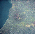
This is an image of Mount Etna in Sicily.
This is a satellite image taken of Mount St. Helens Volcano on October 16, 1994 from STS-64. This volcano erupted on May 18, 1980 in Washington. (Courtesy of Volcano World ?)
This is a false color image of Mount Pinatuba in the Philippines. In the June 1991 eruptions, the main crater was produced and the red shows the rougher ash deposits. The dark drainages are the dangerous mudflows, called "lahars", which are started by heavy rains and will be a major hazard in the area for many years. (Courtesy of NASA/JPL)
This is an image of the volcanoes on Adonara Island in Indonesia. (Courtesy of Aris Multimedia Entertainment, Inc. 1994)

This is an image of the Mauna Loa volcano in Hawaii. It is one of the most active volcanoes on earth and has erupted 15 times since 1900. (Courtesy of Aris Multimedia Entertainment, Inc. 1994)
This is an image of Mt. Shasta volcano in California. It is the second highest mountain in the Cascade Range. (Courtesy of Aris Multimedia Entertainment, Inc. 1994)
Water
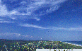
This is an image of the sun reflecting on the ocean (Courtesy of Aris Multimedia Entertainment, Inc. 1994)
This is the Sargasso Sea in the western Atlantic Ocean. It is unusual because it has a lot of seaweed growing in it and floating on the surface. The water is very blue, warm, salty and clear with slowmoving currents but surrounded by much faster currents like the Gulf Stream. (Courtesy of Aris Multimedia Entertainment, Inc. 1994)
This is an image of the Emirates River (Courtesy of Aris Multimedia Entertainment, Inc. 1994)
This is an image of the Colorado River (Courtesy of Aris Multimedia Entertainment, Inc. 1994)
This is an image of the Arabian Gulf of Oman (Courtesy of Aris Multimedia Entertainment, Inc. 1994)
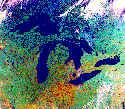
This is a satellite image of the Great Lakes in North America. (Image Courtesy Environmental Research Institute of Michigan, Ann Arbor For additional information see www.erim.org © ERIM)
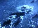
The Oceans and Sea Floor

The seafloor, showing deep trenches near the western edge of the Pacific Ocean. (image courtesy of JPL)
The seafloor, showing deep trenches near the western edge of the Pacific Ocean. (image courtesy of the U.S. Geological Survey)
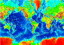
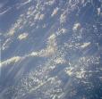
This is an image of topography under the sea.
These are two images of surface elevations in the oceans using two models.
Desert
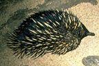
Spiny Anteaters are one of the few mammals that lay eggs. (Image courtesy of Corel Photography)
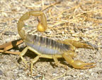
Watch out for the scorpion's tail! (Image courtesy of Corel Photography)
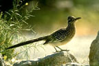
Roadrunners hide in the bushes to stay cool. (Image courtesy of Corel Photography)
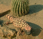
Gila monster. (Image courtesy of Corel Photography)
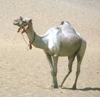
Camel in the desert. (Image courtesy of Corel Photography)
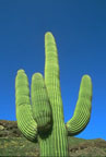
Saguaro cactus. (Image courtesy of Corel Photography)
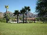
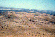
The desert near Palm Springs, California. The Santa Margaurita mountains can be seen in the background. (image courtesy of C. Alexander)

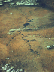
Dry and parched ground from lack of soil moisture. (image courtesy of JPL)
Other Images of Interest
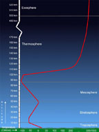
This is an image showing the temperature of the atmosphere throughout different layers. (Windows Original)
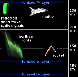
This is an image showing the layers of the atmosphere with emphasis on the ionized layers. (Windows Original)
This is an image of the Grand Canyon in Arizona. It is 277 miles long and up to 18 miles across. The Grand Canyon is the largest canyon in the world and was cut by the Colorado River over millions of years. Some parts are almost a mile deep. (Courtesy of Aris Multimedia Entertainment, Inc. 1994)

Another image of Grand Canyon.
Another image of Grand Canyon.
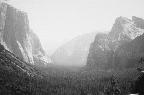
Yosemite National Park.
(image courtesy of C. Alexander)
This is an image of the Gulf of Mexico. It is the largest gulf and covers an area of 596,000 square miles. (Courtesy of Aris Multimedia Entertainment, Inc. 1994)
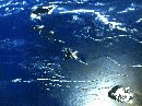
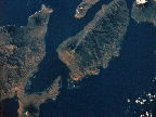
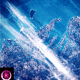
This is an image of the Hawaiian Islands in the Pacific Ocean. (Courtesy of Aris Multimedia Entertainment, Inc. 1994)
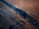
This is an image of the Sahara Desert. It is the largest desert in the world and covers most of the northern third of Africa. (Courtesy of Aris Multimedia Entertainment, Inc. 1994)
This is an image of the San Andreas Fault in California. It is over 750 miles long and marks the boundary between two plates. The plates are sliding by each other about two inches per year. (Courtesy of Aris Multimedia Entertainment, Inc. 1994)
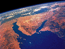
This is an image of the Sinai Desert in the Middle East. (Courtesy of Aris Multimedia Entertainment, Inc. 1994)
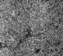
This is a satellite image of Detroit.
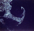
This is a satellite image of Cape Cod, Massachusetts.
This is an image of Mount Everest in the Himalaya range of Asia. It is the highest mountain above sea level - 29,293 feet.
This is a radar image of Washington D.C. The image was acquired by the Spaceborne Imaging Radar-C/X-band Synthetic Aperture Radar (SIR-C/X- SAR) aboard the space shuttle Endeavour on its 150th orbit on April 18, 1994.
This is an image of Grand Traverse Bay, Michigan taken from Skylab of the upper Lake Michigan area.
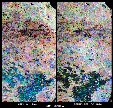
These are two false-color composites of Raco, Michigan, located at the eastern end of Michigan's upper peninsula.
These are two radar images of Yellowstone National Park, Wyoming. It is the oldest national park and is known for its geysers and hot springs.

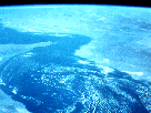
This is an image of the Great Barrier Reef on the east coast of Australia - 2000 kilometers long. This is the largest reef on Earth today. (Courtesy LPI/NASA)
This is a color Infrared image of the San Francisco Bay Area.
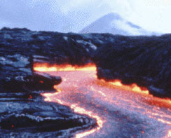
This is an image of lava channels during the eruptions of Pu'u O'o Volcano, Hawaii. The central channel shown here is approximately 4 meters (13 feet) wide. (Courtesy of S. Rowland/LPI)
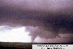
This is a typical image of a tornado spawning from a large cumulonimbus cloud.
(Courtesy of NOAA Storm Spotters Guide and the University of Illinois Cloud Catalog)
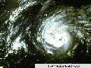
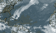
This is a satellite picture of a hurricane over Mississippi and Louisiana. The eye is in the center where there are low winds and no precipitation. (Courtesy of University of Illinois Cloud Catalog)
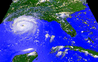
This is a satellite picture of Hurricane Andrew in 1992. (Courtesy of NASA)

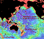
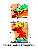
These are images comparing amounts of ozone and ClO between two years. (Courtesy of NASA)

These are images comparing amounts of ozone and ClO between two other years. (Courtesy of NASA)
Go back to Mars , Pluto, Mercury, Saturn, Neptune, Venus, Moon , Jupiter, Asteroids, Comets, Sun , Missions, Uranus, Astrophysical Objects


