The relative location of the Moon and Sun during spring and neap tides. In this diagram, an exaggerated blue ocean around the Earth shows high tides as a thick bulge.
Click on image for full size
Windows to the Universe / Lisa Gardiner
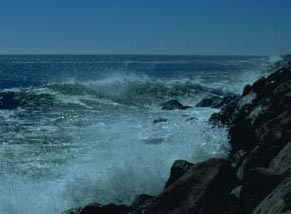
Tides of the Ocean
Each day the ocean surface rises and falls because of tides. The highest point of the rise is called high tide. The lowest point is called low tide. Most places have two high tides and two low tides each day.
Tides happen because of the gravitational pull of the Moon and Sun on ocean water. The Moon has a much greater impact on tides than the Sun because it is much closer. The Moon pulls water that is closest to it making a high tide on the side of the Earth closest to the Moon and there is a high tide on the opposite side of the Earth too. Low tides happen in places between the high tides. Because Earth is rotating, the tides change over time.
The difference between high tide and low tide is called the tidal range. The tidal range can be as little as a few centimeters to as much as several meters depending on the shape of the ocean floor. In Canada's Bay of Fundy the tidal range is very large – 16 meters.
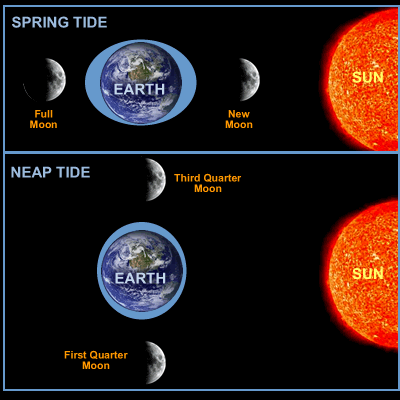
The tidal range changes through the year as the location of the Moon and Sun in relation to Earth changes. At times when the Sun, Earth, and Moon are in line with each other (during full and new moons), the tidal range is larger because both the Sun’s and Moon's gravitational pull create the tide. This is called a spring tide. At times when the Moon and Sun are not in line with Earth, when they are at right angles when viewed from Earth, the tidal range is smaller. This is called a neap tide.
Tides are a powerful force. Scientists and engineers are looking for ways to use some of that power to make electricity. This can be done by channeling tidewater to flow through turbines that generate electricity. These systems may be a danger to wildlife, so scientists are studying tidal ecosystems to understand how they might be affected by turbines.


Shop Windows to the Universe Science Store!
The
Summer 2010 issue of The Earth Scientist, available in our
online store, includes articles on rivers and snow, classroom planetariums, satellites and oceanography, hands-on astronomy, and global warming.
You might also be interested in:

The intertidal zone is the area along a coastline that is underwater at high tide and above the water at low tide. Life in the intertidal zone needs to be able to survive extreme conditions - both above
...more
An aquifer is the name for a layer of rock which is capable of holding a large amount of water. Some layers are better at holding water than others, for example a layer of sandstone can hold a good deal
...more
Carbonate is a name for rocks and minerals which contain a molecule made of both carbon and oxygen known as CO32-. (CO32- is also known as the molecule carbonate). Limestone is an example of a calcium
...more
The deep ocean waters are under pressure and are much colder than layers of the ocean which are closer to the surface. Dissolved carbon dioxide seems to be absent from the deep ocean water and as a result
...more
One process which transfers water from the ground back to the atmosphere is evaporation. Evaporation is when water passes from a liquid phase to a gas phase. Rates of evaporation of water depend on things
...more
The water at the ocean surface is moved primarily by winds that blow in certain patterns because of the Earth’s spin and the Coriolis Effect. Winds are able to move the top 400 meters of the ocean creating
...more
Rivers are very important to Earth because they are major forces that shape the landscape. Also, they provide transportation and water for drinking, washing and farming. Rivers can flow on land or underground
...more