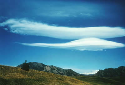
Lenticular, or lee wave, clouds form downwind of an obstacle in the path of a strong air current. In the Boulder, Colorado, area, the obstacle is the Front Range of the Rocky Mountains, seen through clouds at the bottom of the picture.
Click on image for full size
Courtesy of UCAR Digital Image Library
Lenticular
Lenticular clouds form on the downwind side of mountains. Wind blows most types of clouds across the sky, but lenticular clouds seem to stay in one place. Air moves up and over a mountain, and at the point where the air goes past the mountaintop the lenticular cloud forms, and then the air evaporates on the side farther away from the mountains.
As this photo on this page shows, lenticular clouds are lens-shaped and look like flying saucers.
You might also be interested in:

Wind is moving air. Warm air rises, and cool air comes in to take its place. This movement creates different pressures in the atmosphere which creates the winds around the globe. Since the Earth spins,
...more
One process which transfers water from the ground back to the atmosphere is evaporation. Evaporation is when water passes from a liquid phase to a gas phase. Rates of evaporation of water depend on things
...more
Altocumulus clouds are part of the Middle Cloud group (2000-7000m up). They are grayish-white with one part of the cloud darker than the other. Altocumulus clouds usually form in groups and are about
...more
Altostratus belong to the Middle Cloud group (2000-7000m up). An altostratus cloud usually covers the whole sky and has a gray or blue-gray appearance. The sun or moon may shine through an altostratus
...more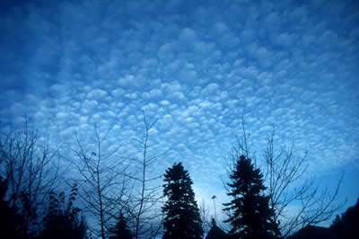
Cirrocumulus clouds belong to the High Cloud group (5000-13000m). They are small rounded puffs that usually appear in long rows. Cirrocumulus are usually white, but sometimes appear gray. Cirrocumulus
...more
Cirrostratus clouds belong to the High Cloud (5000-13000m) group. They are sheetlike thin clouds that usually cover the entire sky. The sun or moon can shine through cirrostratus clouds . Sometimes, the
...more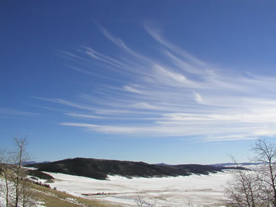
Cirrus clouds are the most common of the High Cloud (5000-13000m) group. They are composed entirely of ice and consist of long, thin, wispy streamers. They are commonly known as "mare's tails" because
...more