Current Events

  • Irish Chronicles Document Links Between Volcanoes and Weather
    A study of over 40,000 written entries in Irish Annals and ice core measurements shows a strong corr...Read more

    x

    Irish Chronicles Document Links Between Volcanoes and Weather

    A study of over 40,000 written entries in Irish Annals and ice core measurements shows a strong correlation between the occurrence of volcanic eruptions and extreme cold weather in Ireland over a 1200 year period. Data analyzed in this study cover the period from 431 to 1649, during which time up to 48 volcanic eruptions are identified in Greenland ice core records through deposition of volcanic sulfate in annual layers of ice. You can find the study (open access), published on 6 June 2013 in IOP Publishing's journal Environmental Research Letters, at http://iopscience.iop.org/1748-9326/8/2/024035/article. Find out more about how volcanoes can influence climate.
  • EF-5 Tornado in El Reno, Oklahoma Widest Ever Recorded in US
    The EF-5 tornado that hit El Reno, Oklahoma on May 31st was the widest ever recorded in the US, acco...Read more

    x

    EF-5 Tornado in El Reno, Oklahoma Widest Ever Recorded in US

    The EF-5 tornado that hit El Reno, Oklahoma on May 31st was the widest ever recorded in the US, according to the National Weather Service in Norman Oklahoma. The tornado, which remained on the ground for 40 minutes and reached 2.6 miles across (4.2 km), took the lives of 18 people including storm chasers Tim Samaras, Paul Samaras and Carl Young. For more information on the tornado, visit http://ow.ly/i/2hfDG.
  • Atmospheric CO2 Level Tops 400 ppm
    During the week of May 13th, the CO2 level at the Mauna Loa Observatory in Hawaii topped 400 ppm rep...Read more

    x

    Atmospheric CO2 Level Tops 400 ppm

    During the week of May 13th, the CO2 level at the Mauna Loa Observatory in Hawaii topped 400 ppm repeatedly. Daily levels of CO2 can vary due to weather, and there are seasonal trends as well. The level of atmospheric greenhouse gases continues to increase, now over 120 ppm since the Industrial Revolution began. For more on the Keeling Curve, see http://keelingcurve.ucsd.edu/. Find out more about greenhouse gases and warming.
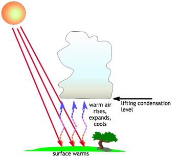
When the Sum warms the Earth, warm air rises into the atmosphere. As it rises, it expands and cools. Water vapor condenses out of the cool air to form a cloud.
Click on image for full size
Image Courtesy of CMMAP

Cloud Formation from Heating of the Earth's Surface

Some clouds form because of the heating of the Earth's surface. First, the Sun heats the ground, which then heats the air. As this warm air rises in the atmosphere, it expands and cools.

The cooling air can't hold as much water vapor as it was able to hold when it was warm. This extra water vapor begins to condense out of the air parcel in the form of liquid water droplets. As the air parcel rises higher and higher, it continues to expand and get cooler, and more moisture condenses out of it.

Eventually, enough moisture will condense out of the air parcel to form a cloud! The types of clouds that form from the process of surface heating are cumulonimbus (and mammatus clouds), cumulus, and stratocumulus.

When the Earth's surface cools instead or warms, fog and stratus clouds can develop.

Last modified May 21, 2009 by Becca Hatheway.

Shop Windows to the Universe Science Store!

The Fall 2009 issue of The Earth Scientist, which includes articles on student research into building design for earthquakes and a classroom lab on the composition of the Earth’s ancient atmosphere, is available in our online store.

Windows to the Universe Community

News

Opportunities

You might also be interested in:

Cool It! Game

Check out our online store - minerals, fossils, books, activities, jewelry, and household items!...more

Condensation

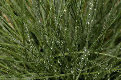
Condensation is when water changes its state from a vapor or gas to a liquid. Condensation is responsible for the formation of clouds. Common examples of condensation are: dew forming on grass in the early...more

Cumulonimbus

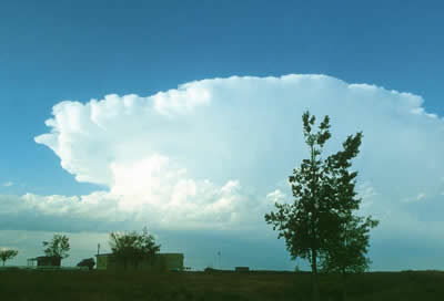
Cumulonimbus clouds belong to the Clouds with Vertical Growth group. They are also known as thunderstorm clouds. A cumulonimbus cloud can grow up to 10km high. At this height, high winds make the top...more

Mammatus

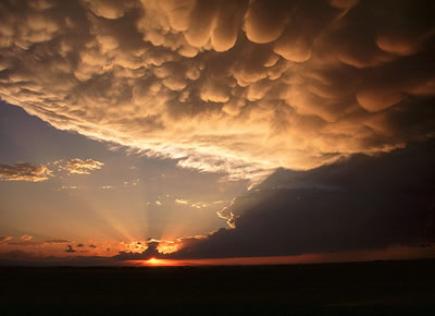
Mammatus clouds are pouches of clouds that hang underneath the base of a cloud. Usually mammatus clouds form with cumulonimbus clouds. Mammatus clouds can look like a field of tennis balls or melons. ...more

Cumulus

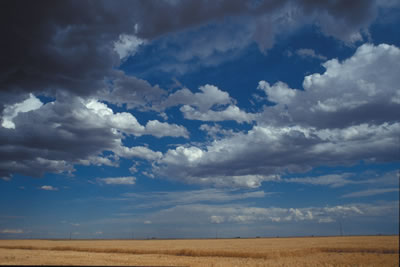
Cumulus clouds belong to the Clouds with Vertical Growth group. They are puffy white or light gray clouds that look like floating cotton balls. Cumulus clouds have sharp outlines and a flat base. Seeing...more

Stratocumulus

Stratocumulus clouds belong to the Low Cloud group. These clouds are low, lumpy, and gray. These clouds can look like cells under a microscope - sometimes they line up in rows and other times they spread...more

Stratus

Stratus clouds are part of the Low Cloud group. They are gray and can cover most or all of the sky (like a big blanket). Stratus clouds sometimes produce light mist or drizzle. ...more

How Clouds Form

A cloud is composed of tiny water droplets or ice crystals. A series of things have to happen in order for these water droplets or ice crystals to form into clouds in the atmosphere, and different types...more

Shop Windows to the Universe

Arches National Park Geology Tour provides an extensive, visually rich description of the geology of Arches, by Deborah Ragland, Ph.D. See our DVD collection.

Windows to the Universe, a project of the National Earth Science Teachers Association, is sponsored in part by the National Science Foundation and NASA, our Founding Partners (the American Geophysical Union and American Geosciences Institute) as well as through Institutional, Contributing, and Affiliate Partners, individual memberships and generous donors. Thank you for your support! NASA AGU AGI NSF